class: inverse, center, middle # <svg aria-hidden="true" role="img" viewBox="0 0 192 512" style="height:1em;width:0.38em;vertical-align:-0.125em;margin-left:auto;margin-right:auto;font-size:inherit;fill:currentColor;overflow:visible;position:relative;"><path d="M144 80c0 26.5-21.5 48-48 48s-48-21.5-48-48s21.5-48 48-48s48 21.5 48 48zM0 224c0-17.7 14.3-32 32-32H96c17.7 0 32 14.3 32 32V448h32c17.7 0 32 14.3 32 32s-14.3 32-32 32H32c-17.7 0-32-14.3-32-32s14.3-32 32-32H64V256H32c-17.7 0-32-14.3-32-32z"/></svg> Shiny spatial ![:custom_hr]() ## <svg aria-hidden="true" role="img" viewBox="0 0 512 512" style="height:1em;width:1em;vertical-align:-0.125em;margin-left:auto;margin-right:auto;font-size:inherit;fill:currentColor;overflow:visible;position:relative;"><path d="M232 120C232 106.7 242.7 96 256 96C269.3 96 280 106.7 280 120V243.2L365.3 300C376.3 307.4 379.3 322.3 371.1 333.3C364.6 344.3 349.7 347.3 338.7 339.1L242.7 275.1C236 271.5 232 264 232 255.1L232 120zM256 0C397.4 0 512 114.6 512 256C512 397.4 397.4 512 256 512C114.6 512 0 397.4 0 256C0 114.6 114.6 0 256 0zM48 256C48 370.9 141.1 464 256 464C370.9 464 464 370.9 464 256C464 141.1 370.9 48 256 48C141.1 48 48 141.1 48 256z"/></svg> ~1h20min --- # Interactive mapping in <svg aria-hidden="true" role="img" viewBox="0 0 581 512" style="height:1em;width:1.13em;vertical-align:-0.125em;margin-left:auto;margin-right:auto;font-size:inherit;fill:currentColor;overflow:visible;position:relative;"><path d="M581 226.6C581 119.1 450.9 32 290.5 32S0 119.1 0 226.6C0 322.4 103.3 402 239.4 418.1V480h99.1v-61.5c24.3-2.7 47.6-7.4 69.4-13.9L448 480h112l-67.4-113.7c54.5-35.4 88.4-84.9 88.4-139.7zm-466.8 14.5c0-73.5 98.9-133 220.8-133s211.9 40.7 211.9 133c0 50.1-26.5 85-70.3 106.4-2.4-1.6-4.7-2.9-6.4-3.7-10.2-5.2-27.8-10.5-27.8-10.5s86.6-6.4 86.6-92.7-90.6-87.9-90.6-87.9h-199V361c-74.1-21.5-125.2-67.1-125.2-119.9zm225.1 38.3v-55.6c57.8 0 87.8-6.8 87.8 27.3 0 36.5-38.2 28.3-87.8 28.3zm-.9 72.5H365c10.8 0 18.9 11.7 24 19.2-16.1 1.9-33 2.8-50.6 2.9v-22.1z"/></svg> ### **Interactive visualization in general** .pull-left[ - [`plotly`](https://cran.r-project.org/package=plotly) - uses [Plotly.js](https://plotly.com/javascript/) - [`highcharter`](https://cran.r-project.org/package=highcharter) - uses [Highcharts.js](https://jkunst.com/highcharter/) ] -- .pull-right[ *Work well with vectorized spatial objects (`sf` and `sp`) in particular. Not so much with rasters yet.* ] -- ### **Interactive mapping in particular** .pull-left[ - [`leaflet`](https://cran.r-project.org/package=leaflet) - uses [Leaflet.js](https://leafletjs.com/) ] -- .pull-right[ *Works well with vectors (`sf` and `sp`) and rasters (`raster` and `stars`)* ] -- ### **<svg aria-hidden="true" role="img" viewBox="0 0 581 512" style="height:1em;width:1.13em;vertical-align:-0.125em;margin-left:auto;margin-right:auto;font-size:inherit;fill:currentColor;overflow:visible;position:relative;"><path d="M581 226.6C581 119.1 450.9 32 290.5 32S0 119.1 0 226.6C0 322.4 103.3 402 239.4 418.1V480h99.1v-61.5c24.3-2.7 47.6-7.4 69.4-13.9L448 480h112l-67.4-113.7c54.5-35.4 88.4-84.9 88.4-139.7zm-466.8 14.5c0-73.5 98.9-133 220.8-133s211.9 40.7 211.9 133c0 50.1-26.5 85-70.3 106.4-2.4-1.6-4.7-2.9-6.4-3.7-10.2-5.2-27.8-10.5-27.8-10.5s86.6-6.4 86.6-92.7-90.6-87.9-90.6-87.9h-199V361c-74.1-21.5-125.2-67.1-125.2-119.9zm225.1 38.3v-55.6c57.8 0 87.8-6.8 87.8 27.3 0 36.5-38.2 28.3-87.8 28.3zm-.9 72.5H365c10.8 0 18.9 11.7 24 19.2-16.1 1.9-33 2.8-50.6 2.9v-22.1z"/></svg> packages expanding `leaflet` capabilities** - [`mapview`](https://cran.r-project.org/package=mapview) - [`tmap`](https://cran.r-project.org/package=tmap) --- # <a href="https://leafletjs.com/"><img src="https://leafletjs.com/docs/images/logo.png" alt="" width="25%"></a> > Leaflet is the leading open-source JavaScript library for mobile-friendly interactive maps. Weighing just about 39 KB of JS, it has all the mapping features most developers ever need. -- <h3>Examples<sup>*</sup></h3> - [The New York Times](https://www.nytimes.com/projects/elections/2013/nyc-primary/mayor/map.html) - [The Washington Post](https://www.washingtonpost.com/sf/local/2013/11/09/washington-a-world-apart/) - [GitHub](https://github.blog/2013-06-13-there-s-a-map-for-that/) - [Open Street Map](https://www.openstreetmap.org/#map=11/46.8543/-71.3414) .font70[ <sup>*</sup>Examples provided in R Studio's [Leaflet for R](https://rstudio.github.io/leaflet/) introduction ] --- # <a href="https://leafletjs.com/"><img src="https://leafletjs.com/docs/images/logo.png" alt="" width="25%"></a> ## <svg aria-hidden="true" role="img" viewBox="0 0 581 512" style="height:1em;width:1.13em;vertical-align:-0.125em;margin-left:auto;margin-right:auto;font-size:inherit;fill:currentColor;overflow:visible;position:relative;"><path d="M581 226.6C581 119.1 450.9 32 290.5 32S0 119.1 0 226.6C0 322.4 103.3 402 239.4 418.1V480h99.1v-61.5c24.3-2.7 47.6-7.4 69.4-13.9L448 480h112l-67.4-113.7c54.5-35.4 88.4-84.9 88.4-139.7zm-466.8 14.5c0-73.5 98.9-133 220.8-133s211.9 40.7 211.9 133c0 50.1-26.5 85-70.3 106.4-2.4-1.6-4.7-2.9-6.4-3.7-10.2-5.2-27.8-10.5-27.8-10.5s86.6-6.4 86.6-92.7-90.6-87.9-90.6-87.9h-199V361c-74.1-21.5-125.2-67.1-125.2-119.9zm225.1 38.3v-55.6c57.8 0 87.8-6.8 87.8 27.3 0 36.5-38.2 28.3-87.8 28.3zm-.9 72.5H365c10.8 0 18.9 11.7 24 19.2-16.1 1.9-33 2.8-50.6 2.9v-22.1z"/></svg> package [`leaflet`](https://cran.r-project.org/package=leaflet) .font90[06/2015 (1.0.0) // 03/2022 (2.1.1)] - The `leaflet` package integrates and controls Leaflet maps through <svg aria-hidden="true" role="img" viewBox="0 0 581 512" style="height:1em;width:1.13em;vertical-align:-0.125em;margin-left:auto;margin-right:auto;font-size:inherit;fill:currentColor;overflow:visible;position:relative;"><path d="M581 226.6C581 119.1 450.9 32 290.5 32S0 119.1 0 226.6C0 322.4 103.3 402 239.4 418.1V480h99.1v-61.5c24.3-2.7 47.6-7.4 69.4-13.9L448 480h112l-67.4-113.7c54.5-35.4 88.4-84.9 88.4-139.7zm-466.8 14.5c0-73.5 98.9-133 220.8-133s211.9 40.7 211.9 133c0 50.1-26.5 85-70.3 106.4-2.4-1.6-4.7-2.9-6.4-3.7-10.2-5.2-27.8-10.5-27.8-10.5s86.6-6.4 86.6-92.7-90.6-87.9-90.6-87.9h-199V361c-74.1-21.5-125.2-67.1-125.2-119.9zm225.1 38.3v-55.6c57.8 0 87.8-6.8 87.8 27.3 0 36.5-38.2 28.3-87.8 28.3zm-.9 72.5H365c10.8 0 18.9 11.7 24 19.2-16.1 1.9-33 2.8-50.6 2.9v-22.1z"/></svg> -- ### **Features** - .font70[full list [here](https://rstudio.github.io/leaflet/)] .font90[ - Interactive panning/zooming - Compose maps using: - Map tiles - Markers - Polygons - Lines - Rasters - Popups - Embed maps in knitr/R Markdown documents and Shiny apps ] --- # Package [`leaflet`](https://cran.r-project.org/package=leaflet) ## Quick map .pull-left[ Leaflet map centered on the St. Lawrence ```r library(leaflet) lf <- leaflet() %>% setView(lng = -63, lat = 48, zoom = 5) addTiles(group = 'Default') lf ``` .font70[See [`setView()`](https://www.rdocumentation.org/packages/leaflet/versions/2.0.3/topics/setView) documentation for more options to set map extent.] ] .pull-right[ <div id="htmlwidget-32d55d47e480e20a36ad" style="width:378px;height:486px;" class="leaflet html-widget"></div> <script type="application/json" data-for="htmlwidget-32d55d47e480e20a36ad">{"x":{"options":{"crs":{"crsClass":"L.CRS.EPSG3857","code":null,"proj4def":null,"projectedBounds":null,"options":{}}},"calls":[{"method":"addTiles","args":["https://{s}.tile.openstreetmap.org/{z}/{x}/{y}.png",null,"Default",{"minZoom":0,"maxZoom":18,"tileSize":256,"subdomains":"abc","errorTileUrl":"","tms":false,"noWrap":false,"zoomOffset":0,"zoomReverse":false,"opacity":1,"zIndex":1,"detectRetina":false,"attribution":"© <a href=\"https://openstreetmap.org\">OpenStreetMap<\/a> contributors, <a href=\"https://creativecommons.org/licenses/by-sa/2.0/\">CC-BY-SA<\/a>"}]}],"setView":[[48,-63],5,[]]},"evals":[],"jsHooks":[]}</script> ] --- # Package [`leaflet`](https://cran.r-project.org/package=leaflet) ## Base maps .pull-left[ `addTiles()` uses [OpenStreetMap](https://www.openstreetmap.org/) as default base map. Use `addProviderTiles()` for other options. ```r leaflet() %>% setView(lng = -63, lat = 48, zoom = 5) %>% addProviderTiles('Esri.OceanBasemap', group = 'Ocean') ``` .font90[Full provider list [here](http://leaflet-extras.github.io/leaflet-providers/preview/index.html)] ] .pull-right[ <div id="htmlwidget-05f1b33c6caac54ec53d" style="width:378px;height:486px;" class="leaflet html-widget"></div> <script type="application/json" data-for="htmlwidget-05f1b33c6caac54ec53d">{"x":{"options":{"crs":{"crsClass":"L.CRS.EPSG3857","code":null,"proj4def":null,"projectedBounds":null,"options":{}}},"setView":[[48,-63],5,[]],"calls":[{"method":"addProviderTiles","args":["Esri.OceanBasemap",null,"Ocean",{"errorTileUrl":"","noWrap":false,"detectRetina":false}]}]},"evals":[],"jsHooks":[]}</script> ] --- # Package [`leaflet`](https://cran.r-project.org/package=leaflet) ## Multiple base maps .pull-left[ Use [`addLayersControl()`](https://www.rdocumentation.org/packages/leaflet/versions/2.0.3/topics/addLayersControl) to toggle base map selection. .font90[ ```r lf <- lf %>% addProviderTiles('Esri.OceanBasemap', group = 'Ocean') %>% addProviderTiles("OpenTopoMap", group = "Topo") %>% # Add layer selection addLayersControl( baseGroups = c('Default','Ocean', 'Topo'), position = 'topleft') lf ``` Note that we are adding features to the preexisting `lf` object ] ] .pull-right[ <div id="htmlwidget-2beb933386a24c64daab" style="width:378px;height:486px;" class="leaflet html-widget"></div> <script type="application/json" data-for="htmlwidget-2beb933386a24c64daab">{"x":{"options":{"crs":{"crsClass":"L.CRS.EPSG3857","code":null,"proj4def":null,"projectedBounds":null,"options":{}}},"calls":[{"method":"addTiles","args":["https://{s}.tile.openstreetmap.org/{z}/{x}/{y}.png",null,"Default",{"minZoom":0,"maxZoom":18,"tileSize":256,"subdomains":"abc","errorTileUrl":"","tms":false,"noWrap":false,"zoomOffset":0,"zoomReverse":false,"opacity":1,"zIndex":1,"detectRetina":false,"attribution":"© <a href=\"https://openstreetmap.org\">OpenStreetMap<\/a> contributors, <a href=\"https://creativecommons.org/licenses/by-sa/2.0/\">CC-BY-SA<\/a>"}]},{"method":"addProviderTiles","args":["Esri.OceanBasemap",null,"Ocean",{"errorTileUrl":"","noWrap":false,"detectRetina":false}]},{"method":"addProviderTiles","args":["OpenTopoMap",null,"Topo",{"errorTileUrl":"","noWrap":false,"detectRetina":false}]},{"method":"addLayersControl","args":[["Default","Ocean","Topo"],[],{"collapsed":true,"autoZIndex":true,"position":"topleft"}]}],"setView":[[48,-63],5,[]]},"evals":[],"jsHooks":[]}</script> ] --- # Package [`leaflet`](https://cran.r-project.org/package=leaflet) ## Add stuff! - Popups: [`leaflet::addPopups`](https://www.rdocumentation.org/packages/leaflet/versions/2.1.1/topics/addControl) - Markers: [`leaflet::addMarkers`](https://www.rdocumentation.org/packages/leaflet/versions/2.1.1/topics/addControl) - Circles: [`leaflet::addCircles`](https://www.rdocumentation.org/packages/leaflet/versions/2.1.1/topics/addControl) - Rectangles: [`leaflet::addRectangles`](https://www.rdocumentation.org/packages/leaflet/versions/2.1.1/topics/addControl) - Legends: [`leaflet::addLegend`](https://www.rdocumentation.org/packages/leaflet/versions/2.1.1/topics/addLegend) - Lines: [`leaflet::addPolylines`](https://www.rdocumentation.org/packages/leaflet/versions/2.1.1/topics/addControl) - Polygons [`leaflet::addPolygons`](https://www.rdocumentation.org/packages/leaflet/versions/2.1.1/topics/addControl) - Rasters: [`leaflet::addRasterImage`](https://www.rdocumentation.org/packages/leaflet/versions/2.1.1/topics/addRasterImage), [`leafem::addStarsImage`](https://rdrr.io/github/r-spatial/leafem/man/addStarsImage.html) - ... .font90[<svg aria-hidden="true" role="img" viewBox="0 0 192 512" style="height:1em;width:0.38em;vertical-align:-0.125em;margin-left:auto;margin-right:auto;font-size:inherit;fill:currentColor;overflow:visible;position:relative;"><path d="M144 80c0 26.5-21.5 48-48 48s-48-21.5-48-48s21.5-48 48-48s48 21.5 48 48zM0 224c0-17.7 14.3-32 32-32H96c17.7 0 32 14.3 32 32V448h32c17.7 0 32 14.3 32 32s-14.3 32-32 32H32c-17.7 0-32-14.3-32-32s14.3-32 32-32H64V256H32c-17.7 0-32-14.3-32-32z"/></svg> see [leaflet documentation](https://www.rdocumentation.org/packages/leaflet/versions/2.1.1) and [Leaflet for R](https://rstudio.github.io/leaflet/) for more] .font90[<svg aria-hidden="true" role="img" viewBox="0 0 192 512" style="height:1em;width:0.38em;vertical-align:-0.125em;margin-left:auto;margin-right:auto;font-size:inherit;fill:currentColor;overflow:visible;position:relative;"><path d="M144 80c0 26.5-21.5 48-48 48s-48-21.5-48-48s21.5-48 48-48s48 21.5 48 48zM0 224c0-17.7 14.3-32 32-32H96c17.7 0 32 14.3 32 32V448h32c17.7 0 32 14.3 32 32s-14.3 32-32 32H32c-17.7 0-32-14.3-32-32s14.3-32 32-32H64V256H32c-17.7 0-32-14.3-32-32z"/></svg> also see this [Cheatsheet](https://raw.githubusercontent.com/rstudio/cheatsheets/master/leaflet.pdf) for leaflet in <svg aria-hidden="true" role="img" viewBox="0 0 581 512" style="height:1em;width:1.13em;vertical-align:-0.125em;margin-left:auto;margin-right:auto;font-size:inherit;fill:currentColor;overflow:visible;position:relative;"><path d="M581 226.6C581 119.1 450.9 32 290.5 32S0 119.1 0 226.6C0 322.4 103.3 402 239.4 418.1V480h99.1v-61.5c24.3-2.7 47.6-7.4 69.4-13.9L448 480h112l-67.4-113.7c54.5-35.4 88.4-84.9 88.4-139.7zm-466.8 14.5c0-73.5 98.9-133 220.8-133s211.9 40.7 211.9 133c0 50.1-26.5 85-70.3 106.4-2.4-1.6-4.7-2.9-6.4-3.7-10.2-5.2-27.8-10.5-27.8-10.5s86.6-6.4 86.6-92.7-90.6-87.9-90.6-87.9h-199V361c-74.1-21.5-125.2-67.1-125.2-119.9zm225.1 38.3v-55.6c57.8 0 87.8-6.8 87.8 27.3 0 36.5-38.2 28.3-87.8 28.3zm-.9 72.5H365c10.8 0 18.9 11.7 24 19.2-16.1 1.9-33 2.8-50.6 2.9v-22.1z"/></svg>] --- # `leaflet` + `shiny` ## General environment ```r library(leaflet) ``` ## `ui` <svg aria-hidden="true" role="img" viewBox="0 0 576 512" style="height:1em;width:1.12em;vertical-align:-0.125em;margin-left:auto;margin-right:auto;font-size:inherit;fill:currentColor;overflow:visible;position:relative;"><path d="M160 256C160 185.3 217.3 128 288 128C358.7 128 416 185.3 416 256C416 326.7 358.7 384 288 384C217.3 384 160 326.7 160 256zM288 336C332.2 336 368 300.2 368 256C368 211.8 332.2 176 288 176C287.3 176 286.7 176 285.1 176C287.3 181.1 288 186.5 288 192C288 227.3 259.3 256 224 256C218.5 256 213.1 255.3 208 253.1C208 254.7 208 255.3 208 255.1C208 300.2 243.8 336 288 336L288 336zM95.42 112.6C142.5 68.84 207.2 32 288 32C368.8 32 433.5 68.84 480.6 112.6C527.4 156 558.7 207.1 573.5 243.7C576.8 251.6 576.8 260.4 573.5 268.3C558.7 304 527.4 355.1 480.6 399.4C433.5 443.2 368.8 480 288 480C207.2 480 142.5 443.2 95.42 399.4C48.62 355.1 17.34 304 2.461 268.3C-.8205 260.4-.8205 251.6 2.461 243.7C17.34 207.1 48.62 156 95.42 112.6V112.6zM288 80C222.8 80 169.2 109.6 128.1 147.7C89.6 183.5 63.02 225.1 49.44 256C63.02 286 89.6 328.5 128.1 364.3C169.2 402.4 222.8 432 288 432C353.2 432 406.8 402.4 447.9 364.3C486.4 328.5 512.1 286 526.6 256C512.1 225.1 486.4 183.5 447.9 147.7C406.8 109.6 353.2 80 288 80V80z"/></svg> ```r leafletOutput(inputId = "mapId", ...) ``` ## `server` <svg aria-hidden="true" role="img" viewBox="0 0 640 512" style="height:1em;width:1.25em;vertical-align:-0.125em;margin-left:auto;margin-right:auto;font-size:inherit;fill:currentColor;overflow:visible;position:relative;"><path d="M308.5 135.3c7.1-6.3 9.9-16.2 6.2-25c-2.3-5.3-4.8-10.5-7.6-15.5L304 89.4c-3-5-6.3-9.9-9.8-14.6c-5.7-7.6-15.7-10.1-24.7-7.1l-28.2 9.3c-10.7-8.8-23-16-36.2-20.9L199 27.1c-1.9-9.3-9.1-16.7-18.5-17.8C173.7 8.4 166.9 8 160 8s-13.7 .4-20.4 1.2c-9.4 1.1-16.6 8.6-18.5 17.8L115 56.1c-13.3 5-25.5 12.1-36.2 20.9L50.5 67.8c-9-3-19-.5-24.7 7.1c-3.5 4.7-6.8 9.6-9.9 14.6l-3 5.3c-2.8 5-5.3 10.2-7.6 15.6c-3.7 8.7-.9 18.6 6.2 25l22.2 19.8C32.6 161.9 32 168.9 32 176s.6 14.1 1.7 20.9L11.5 216.7c-7.1 6.3-9.9 16.2-6.2 25c2.3 5.3 4.8 10.5 7.6 15.6l3 5.2c3 5.1 6.3 9.9 9.9 14.6c5.7 7.6 15.7 10.1 24.7 7.1l28.2-9.3c10.7 8.8 23 16 36.2 20.9l6.1 29.1c1.9 9.3 9.1 16.7 18.5 17.8c6.7 .8 13.5 1.2 20.4 1.2s13.7-.4 20.4-1.2c9.4-1.1 16.6-8.6 18.5-17.8l6.1-29.1c13.3-5 25.5-12.1 36.2-20.9l28.2 9.3c9 3 19 .5 24.7-7.1c3.5-4.7 6.8-9.5 9.8-14.6l3.1-5.4c2.8-5 5.3-10.2 7.6-15.5c3.7-8.7 .9-18.6-6.2-25l-22.2-19.8c1.1-6.8 1.7-13.8 1.7-20.9s-.6-14.1-1.7-20.9l22.2-19.8zM208 176c0 26.5-21.5 48-48 48s-48-21.5-48-48s21.5-48 48-48s48 21.5 48 48zM504.7 500.5c6.3 7.1 16.2 9.9 25 6.2c5.3-2.3 10.5-4.8 15.5-7.6l5.4-3.1c5-3 9.9-6.3 14.6-9.8c7.6-5.7 10.1-15.7 7.1-24.7l-9.3-28.2c8.8-10.7 16-23 20.9-36.2l29.1-6.1c9.3-1.9 16.7-9.1 17.8-18.5c.8-6.7 1.2-13.5 1.2-20.4s-.4-13.7-1.2-20.4c-1.1-9.4-8.6-16.6-17.8-18.5L583.9 307c-5-13.3-12.1-25.5-20.9-36.2l9.3-28.2c3-9 .5-19-7.1-24.7c-4.7-3.5-9.6-6.8-14.6-9.9l-5.3-3c-5-2.8-10.2-5.3-15.6-7.6c-8.7-3.7-18.6-.9-25 6.2l-19.8 22.2c-6.8-1.1-13.8-1.7-20.9-1.7s-14.1 .6-20.9 1.7l-19.8-22.2c-6.3-7.1-16.2-9.9-25-6.2c-5.3 2.3-10.5 4.8-15.6 7.6l-5.2 3c-5.1 3-9.9 6.3-14.6 9.9c-7.6 5.7-10.1 15.7-7.1 24.7l9.3 28.2c-8.8 10.7-16 23-20.9 36.2L315.1 313c-9.3 1.9-16.7 9.1-17.8 18.5c-.8 6.7-1.2 13.5-1.2 20.4s.4 13.7 1.2 20.4c1.1 9.4 8.6 16.6 17.8 18.5l29.1 6.1c5 13.3 12.1 25.5 20.9 36.2l-9.3 28.2c-3 9-.5 19 7.1 24.7c4.7 3.5 9.5 6.8 14.6 9.8l5.4 3.1c5 2.8 10.2 5.3 15.5 7.6c8.7 3.7 18.6 .9 25-6.2l19.8-22.2c6.8 1.1 13.8 1.7 20.9 1.7s14.1-.6 20.9-1.7l19.8 22.2zM464 400c-26.5 0-48-21.5-48-48s21.5-48 48-48s48 21.5 48 48s-21.5 48-48 48z"/></svg> ```r output$mapId <- renderLeaflet({ ... }) ``` --- class: inverse, center, middle # <svg aria-hidden="true" role="img" viewBox="0 0 192 512" style="height:1em;width:0.38em;vertical-align:-0.125em;margin-left:auto;margin-right:auto;font-size:inherit;fill:currentColor;overflow:visible;position:relative;"><path d="M144 80c0 26.5-21.5 48-48 48s-48-21.5-48-48s21.5-48 48-48s48 21.5 48 48zM0 224c0-17.7 14.3-32 32-32H96c17.7 0 32 14.3 32 32V448h32c17.7 0 32 14.3 32 32s-14.3 32-32 32H32c-17.7 0-32-14.3-32-32s14.3-32 32-32H64V256H32c-17.7 0-32-14.3-32-32z"/></svg> Practice 2 ![:custom_hr]() --- # Interactive spatial shiny app ***Context*** > After some discussion, the partner would like us to add some new spatial feature. We will add a new tab with the bird density polygons and two new sliders to specify a bbox area (latitude and longitude range). -- ***Objective*** > Extend our application to filter and visualize a map of bird densities --- # Interactive spatial shiny app ***Data*** <svg aria-hidden="true" role="img" viewBox="0 0 448 512" style="height:1em;width:0.88em;vertical-align:-0.125em;margin-left:auto;margin-right:auto;font-size:inherit;fill:currentColor;overflow:visible;position:relative;"><path d="M448 80v48c0 44.2-100.3 80-224 80S0 172.2 0 128V80C0 35.8 100.3 0 224 0S448 35.8 448 80zM393.2 214.7c20.8-7.4 39.9-16.9 54.8-28.6V288c0 44.2-100.3 80-224 80S0 332.2 0 288V186.1c14.9 11.8 34 21.2 54.8 28.6C99.7 230.7 159.5 240 224 240s124.3-9.3 169.2-25.3zM0 346.1c14.9 11.8 34 21.2 54.8 28.6C99.7 390.7 159.5 400 224 400s124.3-9.3 169.2-25.3c20.8-7.4 39.9-16.9 54.8-28.6V432c0 44.2-100.3 80-224 80S0 476.2 0 432V346.1z"/></svg> - atlas grid -- ***layout*** (ui) <svg aria-hidden="true" role="img" viewBox="0 0 576 512" style="height:1em;width:1.12em;vertical-align:-0.125em;margin-left:auto;margin-right:auto;font-size:inherit;fill:currentColor;overflow:visible;position:relative;"><path d="M160 256C160 185.3 217.3 128 288 128C358.7 128 416 185.3 416 256C416 326.7 358.7 384 288 384C217.3 384 160 326.7 160 256zM288 336C332.2 336 368 300.2 368 256C368 211.8 332.2 176 288 176C287.3 176 286.7 176 285.1 176C287.3 181.1 288 186.5 288 192C288 227.3 259.3 256 224 256C218.5 256 213.1 255.3 208 253.1C208 254.7 208 255.3 208 255.1C208 300.2 243.8 336 288 336L288 336zM95.42 112.6C142.5 68.84 207.2 32 288 32C368.8 32 433.5 68.84 480.6 112.6C527.4 156 558.7 207.1 573.5 243.7C576.8 251.6 576.8 260.4 573.5 268.3C558.7 304 527.4 355.1 480.6 399.4C433.5 443.2 368.8 480 288 480C207.2 480 142.5 443.2 95.42 399.4C48.62 355.1 17.34 304 2.461 268.3C-.8205 260.4-.8205 251.6 2.461 243.7C17.34 207.1 48.62 156 95.42 112.6V112.6zM288 80C222.8 80 169.2 109.6 128.1 147.7C89.6 183.5 63.02 225.1 49.44 256C63.02 286 89.6 328.5 128.1 364.3C169.2 402.4 222.8 432 288 432C353.2 432 406.8 402.4 447.9 364.3C486.4 328.5 512.1 286 526.6 256C512.1 225.1 486.4 183.5 447.9 147.7C406.8 109.6 353.2 80 288 80V80z"/></svg> - tabs in main panel -- ***user inputs*** (ui) <svg aria-hidden="true" role="img" viewBox="0 0 576 512" style="height:1em;width:1.12em;vertical-align:-0.125em;margin-left:auto;margin-right:auto;font-size:inherit;fill:currentColor;overflow:visible;position:relative;"><path d="M160 256C160 185.3 217.3 128 288 128C358.7 128 416 185.3 416 256C416 326.7 358.7 384 288 384C217.3 384 160 326.7 160 256zM288 336C332.2 336 368 300.2 368 256C368 211.8 332.2 176 288 176C287.3 176 286.7 176 285.1 176C287.3 181.1 288 186.5 288 192C288 227.3 259.3 256 224 256C218.5 256 213.1 255.3 208 253.1C208 254.7 208 255.3 208 255.1C208 300.2 243.8 336 288 336L288 336zM95.42 112.6C142.5 68.84 207.2 32 288 32C368.8 32 433.5 68.84 480.6 112.6C527.4 156 558.7 207.1 573.5 243.7C576.8 251.6 576.8 260.4 573.5 268.3C558.7 304 527.4 355.1 480.6 399.4C433.5 443.2 368.8 480 288 480C207.2 480 142.5 443.2 95.42 399.4C48.62 355.1 17.34 304 2.461 268.3C-.8205 260.4-.8205 251.6 2.461 243.7C17.34 207.1 48.62 156 95.42 112.6V112.6zM288 80C222.8 80 169.2 109.6 128.1 147.7C89.6 183.5 63.02 225.1 49.44 256C63.02 286 89.6 328.5 128.1 364.3C169.2 402.4 222.8 432 288 432C353.2 432 406.8 402.4 447.9 364.3C486.4 328.5 512.1 286 526.6 256C512.1 225.1 486.4 183.5 447.9 147.7C406.8 109.6 353.2 80 288 80V80z"/></svg> - slider input: `longitude` - slider input: `latitude` -- ***server output*** <svg aria-hidden="true" role="img" viewBox="0 0 640 512" style="height:1em;width:1.25em;vertical-align:-0.125em;margin-left:auto;margin-right:auto;font-size:inherit;fill:currentColor;overflow:visible;position:relative;"><path d="M308.5 135.3c7.1-6.3 9.9-16.2 6.2-25c-2.3-5.3-4.8-10.5-7.6-15.5L304 89.4c-3-5-6.3-9.9-9.8-14.6c-5.7-7.6-15.7-10.1-24.7-7.1l-28.2 9.3c-10.7-8.8-23-16-36.2-20.9L199 27.1c-1.9-9.3-9.1-16.7-18.5-17.8C173.7 8.4 166.9 8 160 8s-13.7 .4-20.4 1.2c-9.4 1.1-16.6 8.6-18.5 17.8L115 56.1c-13.3 5-25.5 12.1-36.2 20.9L50.5 67.8c-9-3-19-.5-24.7 7.1c-3.5 4.7-6.8 9.6-9.9 14.6l-3 5.3c-2.8 5-5.3 10.2-7.6 15.6c-3.7 8.7-.9 18.6 6.2 25l22.2 19.8C32.6 161.9 32 168.9 32 176s.6 14.1 1.7 20.9L11.5 216.7c-7.1 6.3-9.9 16.2-6.2 25c2.3 5.3 4.8 10.5 7.6 15.6l3 5.2c3 5.1 6.3 9.9 9.9 14.6c5.7 7.6 15.7 10.1 24.7 7.1l28.2-9.3c10.7 8.8 23 16 36.2 20.9l6.1 29.1c1.9 9.3 9.1 16.7 18.5 17.8c6.7 .8 13.5 1.2 20.4 1.2s13.7-.4 20.4-1.2c9.4-1.1 16.6-8.6 18.5-17.8l6.1-29.1c13.3-5 25.5-12.1 36.2-20.9l28.2 9.3c9 3 19 .5 24.7-7.1c3.5-4.7 6.8-9.5 9.8-14.6l3.1-5.4c2.8-5 5.3-10.2 7.6-15.5c3.7-8.7 .9-18.6-6.2-25l-22.2-19.8c1.1-6.8 1.7-13.8 1.7-20.9s-.6-14.1-1.7-20.9l22.2-19.8zM208 176c0 26.5-21.5 48-48 48s-48-21.5-48-48s21.5-48 48-48s48 21.5 48 48zM504.7 500.5c6.3 7.1 16.2 9.9 25 6.2c5.3-2.3 10.5-4.8 15.5-7.6l5.4-3.1c5-3 9.9-6.3 14.6-9.8c7.6-5.7 10.1-15.7 7.1-24.7l-9.3-28.2c8.8-10.7 16-23 20.9-36.2l29.1-6.1c9.3-1.9 16.7-9.1 17.8-18.5c.8-6.7 1.2-13.5 1.2-20.4s-.4-13.7-1.2-20.4c-1.1-9.4-8.6-16.6-17.8-18.5L583.9 307c-5-13.3-12.1-25.5-20.9-36.2l9.3-28.2c3-9 .5-19-7.1-24.7c-4.7-3.5-9.6-6.8-14.6-9.9l-5.3-3c-5-2.8-10.2-5.3-15.6-7.6c-8.7-3.7-18.6-.9-25 6.2l-19.8 22.2c-6.8-1.1-13.8-1.7-20.9-1.7s-14.1 .6-20.9 1.7l-19.8-22.2c-6.3-7.1-16.2-9.9-25-6.2c-5.3 2.3-10.5 4.8-15.6 7.6l-5.2 3c-5.1 3-9.9 6.3-14.6 9.9c-7.6 5.7-10.1 15.7-7.1 24.7l9.3 28.2c-8.8 10.7-16 23-20.9 36.2L315.1 313c-9.3 1.9-16.7 9.1-17.8 18.5c-.8 6.7-1.2 13.5-1.2 20.4s.4 13.7 1.2 20.4c1.1 9.4 8.6 16.6 17.8 18.5l29.1 6.1c5 13.3 12.1 25.5 20.9 36.2l-9.3 28.2c-3 9-.5 19 7.1 24.7c4.7 3.5 9.5 6.8 14.6 9.8l5.4 3.1c5 2.8 10.2 5.3 15.5 7.6c8.7 3.7 18.6 .9 25-6.2l19.8-22.2c6.8 1.1 13.8 1.7 20.9 1.7s14.1-.6 20.9-1.7l19.8 22.2zM464 400c-26.5 0-48-21.5-48-48s21.5-48 48-48s48 21.5 48 48s-21.5 48-48 48z"/></svg> - filter atlas with bounding box - join density data to atlas - render leaflet map with densities --- # Interactive spatial shiny app .pull-left[ ***Data*** <svg aria-hidden="true" role="img" viewBox="0 0 448 512" style="height:1em;width:0.88em;vertical-align:-0.125em;margin-left:auto;margin-right:auto;font-size:inherit;fill:currentColor;overflow:visible;position:relative;"><path d="M448 80v48c0 44.2-100.3 80-224 80S0 172.2 0 128V80C0 35.8 100.3 0 224 0S448 35.8 448 80zM393.2 214.7c20.8-7.4 39.9-16.9 54.8-28.6V288c0 44.2-100.3 80-224 80S0 332.2 0 288V186.1c14.9 11.8 34 21.2 54.8 28.6C99.7 230.7 159.5 240 224 240s124.3-9.3 169.2-25.3zM0 346.1c14.9 11.8 34 21.2 54.8 28.6C99.7 390.7 159.5 400 224 400s124.3-9.3 169.2-25.3c20.8-7.4 39.9-16.9 54.8-28.6V432c0 44.2-100.3 80-224 80S0 476.2 0 432V346.1z"/></svg> - atlas grid ] .pull-right[ ***What to do*** - Import atlas grid as global variable - `dsn = "AtlasGrid-GrilleAtlas.gdb"` - `layer = "AtlasGrid_GrilleAtlas"` - Transform projection to WGS84 standard (`epsg:4326`) .font80[<svg aria-hidden="true" role="img" viewBox="0 0 192 512" style="height:1em;width:0.38em;vertical-align:-0.125em;margin-left:auto;margin-right:auto;font-size:inherit;fill:currentColor;overflow:visible;position:relative;"><path d="M144 80c0 26.5-21.5 48-48 48s-48-21.5-48-48s21.5-48 48-48s48 21.5 48 48zM0 224c0-17.7 14.3-32 32-32H96c17.7 0 32 14.3 32 32V448h32c17.7 0 32 14.3 32 32s-14.3 32-32 32H32c-17.7 0-32-14.3-32-32s14.3-32 32-32H64V256H32c-17.7 0-32-14.3-32-32z"/></svg> see [`sf::st_read`](https://r-spatial.github.io/sf/reference/st_read.html) to learn how to import a geodatabase] .font80[<svg aria-hidden="true" role="img" viewBox="0 0 192 512" style="height:1em;width:0.38em;vertical-align:-0.125em;margin-left:auto;margin-right:auto;font-size:inherit;fill:currentColor;overflow:visible;position:relative;"><path d="M144 80c0 26.5-21.5 48-48 48s-48-21.5-48-48s21.5-48 48-48s48 21.5 48 48zM0 224c0-17.7 14.3-32 32-32H96c17.7 0 32 14.3 32 32V448h32c17.7 0 32 14.3 32 32s-14.3 32-32 32H32c-17.7 0-32-14.3-32-32s14.3-32 32-32H64V256H32c-17.7 0-32-14.3-32-32z"/></svg> see [`sf::st_transform`](https://r-spatial.github.io/sf/reference/st_transform.html) to learn how to transform projection of `sf` object] ] <div class="countdown" id="timer_3aff2ac5" data-update-every="1" tabindex="0" style="right:0;bottom:0;margin:0.75em;"> <div class="countdown-controls"><button class="countdown-bump-down">−</button><button class="countdown-bump-up">+</button></div> <code class="countdown-time"><span class="countdown-digits minutes">10</span><span class="countdown-digits colon">:</span><span class="countdown-digits seconds">00</span></code> </div> --- # Interactive spatial shiny app .pull-left[ ***Data*** <svg aria-hidden="true" role="img" viewBox="0 0 448 512" style="height:1em;width:0.88em;vertical-align:-0.125em;margin-left:auto;margin-right:auto;font-size:inherit;fill:currentColor;overflow:visible;position:relative;"><path d="M448 80v48c0 44.2-100.3 80-224 80S0 172.2 0 128V80C0 35.8 100.3 0 224 0S448 35.8 448 80zM393.2 214.7c20.8-7.4 39.9-16.9 54.8-28.6V288c0 44.2-100.3 80-224 80S0 332.2 0 288V186.1c14.9 11.8 34 21.2 54.8 28.6C99.7 230.7 159.5 240 224 240s124.3-9.3 169.2-25.3zM0 346.1c14.9 11.8 34 21.2 54.8 28.6C99.7 390.7 159.5 400 224 400s124.3-9.3 169.2-25.3c20.8-7.4 39.9-16.9 54.8-28.6V432c0 44.2-100.3 80-224 80S0 476.2 0 432V346.1z"/></svg> - atlas grid <svg aria-hidden="true" role="img" viewBox="0 0 512 512" style="height:1em;width:1em;vertical-align:-0.125em;margin-left:auto;margin-right:auto;font-size:inherit;fill:currentColor;overflow:visible;position:relative;"><path d="M470.6 105.4c12.5 12.5 12.5 32.8 0 45.3l-256 256c-12.5 12.5-32.8 12.5-45.3 0l-128-128c-12.5-12.5-12.5-32.8 0-45.3s32.8-12.5 45.3 0L192 338.7 425.4 105.4c12.5-12.5 32.8-12.5 45.3 0z"/></svg> ***layout*** (ui) <svg aria-hidden="true" role="img" viewBox="0 0 576 512" style="height:1em;width:1.12em;vertical-align:-0.125em;margin-left:auto;margin-right:auto;font-size:inherit;fill:currentColor;overflow:visible;position:relative;"><path d="M160 256C160 185.3 217.3 128 288 128C358.7 128 416 185.3 416 256C416 326.7 358.7 384 288 384C217.3 384 160 326.7 160 256zM288 336C332.2 336 368 300.2 368 256C368 211.8 332.2 176 288 176C287.3 176 286.7 176 285.1 176C287.3 181.1 288 186.5 288 192C288 227.3 259.3 256 224 256C218.5 256 213.1 255.3 208 253.1C208 254.7 208 255.3 208 255.1C208 300.2 243.8 336 288 336L288 336zM95.42 112.6C142.5 68.84 207.2 32 288 32C368.8 32 433.5 68.84 480.6 112.6C527.4 156 558.7 207.1 573.5 243.7C576.8 251.6 576.8 260.4 573.5 268.3C558.7 304 527.4 355.1 480.6 399.4C433.5 443.2 368.8 480 288 480C207.2 480 142.5 443.2 95.42 399.4C48.62 355.1 17.34 304 2.461 268.3C-.8205 260.4-.8205 251.6 2.461 243.7C17.34 207.1 48.62 156 95.42 112.6V112.6zM288 80C222.8 80 169.2 109.6 128.1 147.7C89.6 183.5 63.02 225.1 49.44 256C63.02 286 89.6 328.5 128.1 364.3C169.2 402.4 222.8 432 288 432C353.2 432 406.8 402.4 447.9 364.3C486.4 328.5 512.1 286 526.6 256C512.1 225.1 486.4 183.5 447.9 147.7C406.8 109.6 353.2 80 288 80V80z"/></svg> - tabs in main panel ] .pull-right[ ***What to do*** - Divide the main panel in two tabs ```r ?tabsetPanel ?tabPanel ``` .font80[<svg aria-hidden="true" role="img" viewBox="0 0 192 512" style="height:1em;width:0.38em;vertical-align:-0.125em;margin-left:auto;margin-right:auto;font-size:inherit;fill:currentColor;overflow:visible;position:relative;"><path d="M144 80c0 26.5-21.5 48-48 48s-48-21.5-48-48s21.5-48 48-48s48 21.5 48 48zM0 224c0-17.7 14.3-32 32-32H96c17.7 0 32 14.3 32 32V448h32c17.7 0 32 14.3 32 32s-14.3 32-32 32H32c-17.7 0-32-14.3-32-32s14.3-32 32-32H64V256H32c-17.7 0-32-14.3-32-32z"/></svg> Go [here](https://shiny.rstudio.com/articles/layout-guide.html) for an example of such a layout] ] <div class="countdown" id="timer_42341113" data-update-every="1" tabindex="0" style="right:0;bottom:0;margin:0.75em;"> <div class="countdown-controls"><button class="countdown-bump-down">−</button><button class="countdown-bump-up">+</button></div> <code class="countdown-time"><span class="countdown-digits minutes">10</span><span class="countdown-digits colon">:</span><span class="countdown-digits seconds">00</span></code> </div> --- # Interactive spatial shiny app .pull-left[ ***Data*** <svg aria-hidden="true" role="img" viewBox="0 0 448 512" style="height:1em;width:0.88em;vertical-align:-0.125em;margin-left:auto;margin-right:auto;font-size:inherit;fill:currentColor;overflow:visible;position:relative;"><path d="M448 80v48c0 44.2-100.3 80-224 80S0 172.2 0 128V80C0 35.8 100.3 0 224 0S448 35.8 448 80zM393.2 214.7c20.8-7.4 39.9-16.9 54.8-28.6V288c0 44.2-100.3 80-224 80S0 332.2 0 288V186.1c14.9 11.8 34 21.2 54.8 28.6C99.7 230.7 159.5 240 224 240s124.3-9.3 169.2-25.3zM0 346.1c14.9 11.8 34 21.2 54.8 28.6C99.7 390.7 159.5 400 224 400s124.3-9.3 169.2-25.3c20.8-7.4 39.9-16.9 54.8-28.6V432c0 44.2-100.3 80-224 80S0 476.2 0 432V346.1z"/></svg> - atlas grid <svg aria-hidden="true" role="img" viewBox="0 0 512 512" style="height:1em;width:1em;vertical-align:-0.125em;margin-left:auto;margin-right:auto;font-size:inherit;fill:currentColor;overflow:visible;position:relative;"><path d="M470.6 105.4c12.5 12.5 12.5 32.8 0 45.3l-256 256c-12.5 12.5-32.8 12.5-45.3 0l-128-128c-12.5-12.5-12.5-32.8 0-45.3s32.8-12.5 45.3 0L192 338.7 425.4 105.4c12.5-12.5 32.8-12.5 45.3 0z"/></svg> ***layout*** (ui) <svg aria-hidden="true" role="img" viewBox="0 0 576 512" style="height:1em;width:1.12em;vertical-align:-0.125em;margin-left:auto;margin-right:auto;font-size:inherit;fill:currentColor;overflow:visible;position:relative;"><path d="M160 256C160 185.3 217.3 128 288 128C358.7 128 416 185.3 416 256C416 326.7 358.7 384 288 384C217.3 384 160 326.7 160 256zM288 336C332.2 336 368 300.2 368 256C368 211.8 332.2 176 288 176C287.3 176 286.7 176 285.1 176C287.3 181.1 288 186.5 288 192C288 227.3 259.3 256 224 256C218.5 256 213.1 255.3 208 253.1C208 254.7 208 255.3 208 255.1C208 300.2 243.8 336 288 336L288 336zM95.42 112.6C142.5 68.84 207.2 32 288 32C368.8 32 433.5 68.84 480.6 112.6C527.4 156 558.7 207.1 573.5 243.7C576.8 251.6 576.8 260.4 573.5 268.3C558.7 304 527.4 355.1 480.6 399.4C433.5 443.2 368.8 480 288 480C207.2 480 142.5 443.2 95.42 399.4C48.62 355.1 17.34 304 2.461 268.3C-.8205 260.4-.8205 251.6 2.461 243.7C17.34 207.1 48.62 156 95.42 112.6V112.6zM288 80C222.8 80 169.2 109.6 128.1 147.7C89.6 183.5 63.02 225.1 49.44 256C63.02 286 89.6 328.5 128.1 364.3C169.2 402.4 222.8 432 288 432C353.2 432 406.8 402.4 447.9 364.3C486.4 328.5 512.1 286 526.6 256C512.1 225.1 486.4 183.5 447.9 147.7C406.8 109.6 353.2 80 288 80V80z"/></svg> - tabs in main panel <svg aria-hidden="true" role="img" viewBox="0 0 512 512" style="height:1em;width:1em;vertical-align:-0.125em;margin-left:auto;margin-right:auto;font-size:inherit;fill:currentColor;overflow:visible;position:relative;"><path d="M470.6 105.4c12.5 12.5 12.5 32.8 0 45.3l-256 256c-12.5 12.5-32.8 12.5-45.3 0l-128-128c-12.5-12.5-12.5-32.8 0-45.3s32.8-12.5 45.3 0L192 338.7 425.4 105.4c12.5-12.5 32.8-12.5 45.3 0z"/></svg> ***user inputs*** (ui) <svg aria-hidden="true" role="img" viewBox="0 0 576 512" style="height:1em;width:1.12em;vertical-align:-0.125em;margin-left:auto;margin-right:auto;font-size:inherit;fill:currentColor;overflow:visible;position:relative;"><path d="M160 256C160 185.3 217.3 128 288 128C358.7 128 416 185.3 416 256C416 326.7 358.7 384 288 384C217.3 384 160 326.7 160 256zM288 336C332.2 336 368 300.2 368 256C368 211.8 332.2 176 288 176C287.3 176 286.7 176 285.1 176C287.3 181.1 288 186.5 288 192C288 227.3 259.3 256 224 256C218.5 256 213.1 255.3 208 253.1C208 254.7 208 255.3 208 255.1C208 300.2 243.8 336 288 336L288 336zM95.42 112.6C142.5 68.84 207.2 32 288 32C368.8 32 433.5 68.84 480.6 112.6C527.4 156 558.7 207.1 573.5 243.7C576.8 251.6 576.8 260.4 573.5 268.3C558.7 304 527.4 355.1 480.6 399.4C433.5 443.2 368.8 480 288 480C207.2 480 142.5 443.2 95.42 399.4C48.62 355.1 17.34 304 2.461 268.3C-.8205 260.4-.8205 251.6 2.461 243.7C17.34 207.1 48.62 156 95.42 112.6V112.6zM288 80C222.8 80 169.2 109.6 128.1 147.7C89.6 183.5 63.02 225.1 49.44 256C63.02 286 89.6 328.5 128.1 364.3C169.2 402.4 222.8 432 288 432C353.2 432 406.8 402.4 447.9 364.3C486.4 328.5 512.1 286 526.6 256C512.1 225.1 486.4 183.5 447.9 147.7C406.8 109.6 353.2 80 288 80V80z"/></svg> - slider input: `longitude` - slider input: `latitude` ***server output*** <svg aria-hidden="true" role="img" viewBox="0 0 640 512" style="height:1em;width:1.25em;vertical-align:-0.125em;margin-left:auto;margin-right:auto;font-size:inherit;fill:currentColor;overflow:visible;position:relative;"><path d="M308.5 135.3c7.1-6.3 9.9-16.2 6.2-25c-2.3-5.3-4.8-10.5-7.6-15.5L304 89.4c-3-5-6.3-9.9-9.8-14.6c-5.7-7.6-15.7-10.1-24.7-7.1l-28.2 9.3c-10.7-8.8-23-16-36.2-20.9L199 27.1c-1.9-9.3-9.1-16.7-18.5-17.8C173.7 8.4 166.9 8 160 8s-13.7 .4-20.4 1.2c-9.4 1.1-16.6 8.6-18.5 17.8L115 56.1c-13.3 5-25.5 12.1-36.2 20.9L50.5 67.8c-9-3-19-.5-24.7 7.1c-3.5 4.7-6.8 9.6-9.9 14.6l-3 5.3c-2.8 5-5.3 10.2-7.6 15.6c-3.7 8.7-.9 18.6 6.2 25l22.2 19.8C32.6 161.9 32 168.9 32 176s.6 14.1 1.7 20.9L11.5 216.7c-7.1 6.3-9.9 16.2-6.2 25c2.3 5.3 4.8 10.5 7.6 15.6l3 5.2c3 5.1 6.3 9.9 9.9 14.6c5.7 7.6 15.7 10.1 24.7 7.1l28.2-9.3c10.7 8.8 23 16 36.2 20.9l6.1 29.1c1.9 9.3 9.1 16.7 18.5 17.8c6.7 .8 13.5 1.2 20.4 1.2s13.7-.4 20.4-1.2c9.4-1.1 16.6-8.6 18.5-17.8l6.1-29.1c13.3-5 25.5-12.1 36.2-20.9l28.2 9.3c9 3 19 .5 24.7-7.1c3.5-4.7 6.8-9.5 9.8-14.6l3.1-5.4c2.8-5 5.3-10.2 7.6-15.5c3.7-8.7 .9-18.6-6.2-25l-22.2-19.8c1.1-6.8 1.7-13.8 1.7-20.9s-.6-14.1-1.7-20.9l22.2-19.8zM208 176c0 26.5-21.5 48-48 48s-48-21.5-48-48s21.5-48 48-48s48 21.5 48 48zM504.7 500.5c6.3 7.1 16.2 9.9 25 6.2c5.3-2.3 10.5-4.8 15.5-7.6l5.4-3.1c5-3 9.9-6.3 14.6-9.8c7.6-5.7 10.1-15.7 7.1-24.7l-9.3-28.2c8.8-10.7 16-23 20.9-36.2l29.1-6.1c9.3-1.9 16.7-9.1 17.8-18.5c.8-6.7 1.2-13.5 1.2-20.4s-.4-13.7-1.2-20.4c-1.1-9.4-8.6-16.6-17.8-18.5L583.9 307c-5-13.3-12.1-25.5-20.9-36.2l9.3-28.2c3-9 .5-19-7.1-24.7c-4.7-3.5-9.6-6.8-14.6-9.9l-5.3-3c-5-2.8-10.2-5.3-15.6-7.6c-8.7-3.7-18.6-.9-25 6.2l-19.8 22.2c-6.8-1.1-13.8-1.7-20.9-1.7s-14.1 .6-20.9 1.7l-19.8-22.2c-6.3-7.1-16.2-9.9-25-6.2c-5.3 2.3-10.5 4.8-15.6 7.6l-5.2 3c-5.1 3-9.9 6.3-14.6 9.9c-7.6 5.7-10.1 15.7-7.1 24.7l9.3 28.2c-8.8 10.7-16 23-20.9 36.2L315.1 313c-9.3 1.9-16.7 9.1-17.8 18.5c-.8 6.7-1.2 13.5-1.2 20.4s.4 13.7 1.2 20.4c1.1 9.4 8.6 16.6 17.8 18.5l29.1 6.1c5 13.3 12.1 25.5 20.9 36.2l-9.3 28.2c-3 9-.5 19 7.1 24.7c4.7 3.5 9.5 6.8 14.6 9.8l5.4 3.1c5 2.8 10.2 5.3 15.5 7.6c8.7 3.7 18.6 .9 25-6.2l19.8-22.2c6.8 1.1 13.8 1.7 20.9 1.7s14.1-.6 20.9-1.7l19.8 22.2zM464 400c-26.5 0-48-21.5-48-48s21.5-48 48-48s48 21.5 48 48s-21.5 48-48 48z"/></svg> - filter atlas with bounding box - join density data to atlas - render leaflet map with densities ] .pull-right[ ***What to do*** - Draw the reactive graph for the user inputs and server outputs ] <div class="countdown" id="timer_f2edfa7d" data-update-every="1" tabindex="0" style="right:0;bottom:0;margin:0.75em;"> <div class="countdown-controls"><button class="countdown-bump-down">−</button><button class="countdown-bump-up">+</button></div> <code class="countdown-time"><span class="countdown-digits minutes">05</span><span class="countdown-digits colon">:</span><span class="countdown-digits seconds">00</span></code> </div> --- # Interactive spatial shiny app .pull-left[ ***Data*** <svg aria-hidden="true" role="img" viewBox="0 0 448 512" style="height:1em;width:0.88em;vertical-align:-0.125em;margin-left:auto;margin-right:auto;font-size:inherit;fill:currentColor;overflow:visible;position:relative;"><path d="M448 80v48c0 44.2-100.3 80-224 80S0 172.2 0 128V80C0 35.8 100.3 0 224 0S448 35.8 448 80zM393.2 214.7c20.8-7.4 39.9-16.9 54.8-28.6V288c0 44.2-100.3 80-224 80S0 332.2 0 288V186.1c14.9 11.8 34 21.2 54.8 28.6C99.7 230.7 159.5 240 224 240s124.3-9.3 169.2-25.3zM0 346.1c14.9 11.8 34 21.2 54.8 28.6C99.7 390.7 159.5 400 224 400s124.3-9.3 169.2-25.3c20.8-7.4 39.9-16.9 54.8-28.6V432c0 44.2-100.3 80-224 80S0 476.2 0 432V346.1z"/></svg> - atlas grid <svg aria-hidden="true" role="img" viewBox="0 0 512 512" style="height:1em;width:1em;vertical-align:-0.125em;margin-left:auto;margin-right:auto;font-size:inherit;fill:currentColor;overflow:visible;position:relative;"><path d="M470.6 105.4c12.5 12.5 12.5 32.8 0 45.3l-256 256c-12.5 12.5-32.8 12.5-45.3 0l-128-128c-12.5-12.5-12.5-32.8 0-45.3s32.8-12.5 45.3 0L192 338.7 425.4 105.4c12.5-12.5 32.8-12.5 45.3 0z"/></svg> ***layout*** (ui) <svg aria-hidden="true" role="img" viewBox="0 0 576 512" style="height:1em;width:1.12em;vertical-align:-0.125em;margin-left:auto;margin-right:auto;font-size:inherit;fill:currentColor;overflow:visible;position:relative;"><path d="M160 256C160 185.3 217.3 128 288 128C358.7 128 416 185.3 416 256C416 326.7 358.7 384 288 384C217.3 384 160 326.7 160 256zM288 336C332.2 336 368 300.2 368 256C368 211.8 332.2 176 288 176C287.3 176 286.7 176 285.1 176C287.3 181.1 288 186.5 288 192C288 227.3 259.3 256 224 256C218.5 256 213.1 255.3 208 253.1C208 254.7 208 255.3 208 255.1C208 300.2 243.8 336 288 336L288 336zM95.42 112.6C142.5 68.84 207.2 32 288 32C368.8 32 433.5 68.84 480.6 112.6C527.4 156 558.7 207.1 573.5 243.7C576.8 251.6 576.8 260.4 573.5 268.3C558.7 304 527.4 355.1 480.6 399.4C433.5 443.2 368.8 480 288 480C207.2 480 142.5 443.2 95.42 399.4C48.62 355.1 17.34 304 2.461 268.3C-.8205 260.4-.8205 251.6 2.461 243.7C17.34 207.1 48.62 156 95.42 112.6V112.6zM288 80C222.8 80 169.2 109.6 128.1 147.7C89.6 183.5 63.02 225.1 49.44 256C63.02 286 89.6 328.5 128.1 364.3C169.2 402.4 222.8 432 288 432C353.2 432 406.8 402.4 447.9 364.3C486.4 328.5 512.1 286 526.6 256C512.1 225.1 486.4 183.5 447.9 147.7C406.8 109.6 353.2 80 288 80V80z"/></svg> - tabs in main panel <svg aria-hidden="true" role="img" viewBox="0 0 512 512" style="height:1em;width:1em;vertical-align:-0.125em;margin-left:auto;margin-right:auto;font-size:inherit;fill:currentColor;overflow:visible;position:relative;"><path d="M470.6 105.4c12.5 12.5 12.5 32.8 0 45.3l-256 256c-12.5 12.5-32.8 12.5-45.3 0l-128-128c-12.5-12.5-12.5-32.8 0-45.3s32.8-12.5 45.3 0L192 338.7 425.4 105.4c12.5-12.5 32.8-12.5 45.3 0z"/></svg> ***user inputs*** (ui) <svg aria-hidden="true" role="img" viewBox="0 0 576 512" style="height:1em;width:1.12em;vertical-align:-0.125em;margin-left:auto;margin-right:auto;font-size:inherit;fill:currentColor;overflow:visible;position:relative;"><path d="M160 256C160 185.3 217.3 128 288 128C358.7 128 416 185.3 416 256C416 326.7 358.7 384 288 384C217.3 384 160 326.7 160 256zM288 336C332.2 336 368 300.2 368 256C368 211.8 332.2 176 288 176C287.3 176 286.7 176 285.1 176C287.3 181.1 288 186.5 288 192C288 227.3 259.3 256 224 256C218.5 256 213.1 255.3 208 253.1C208 254.7 208 255.3 208 255.1C208 300.2 243.8 336 288 336L288 336zM95.42 112.6C142.5 68.84 207.2 32 288 32C368.8 32 433.5 68.84 480.6 112.6C527.4 156 558.7 207.1 573.5 243.7C576.8 251.6 576.8 260.4 573.5 268.3C558.7 304 527.4 355.1 480.6 399.4C433.5 443.2 368.8 480 288 480C207.2 480 142.5 443.2 95.42 399.4C48.62 355.1 17.34 304 2.461 268.3C-.8205 260.4-.8205 251.6 2.461 243.7C17.34 207.1 48.62 156 95.42 112.6V112.6zM288 80C222.8 80 169.2 109.6 128.1 147.7C89.6 183.5 63.02 225.1 49.44 256C63.02 286 89.6 328.5 128.1 364.3C169.2 402.4 222.8 432 288 432C353.2 432 406.8 402.4 447.9 364.3C486.4 328.5 512.1 286 526.6 256C512.1 225.1 486.4 183.5 447.9 147.7C406.8 109.6 353.2 80 288 80V80z"/></svg> - slider input: `longitude` - slider input: `latitude` ***server output*** <svg aria-hidden="true" role="img" viewBox="0 0 640 512" style="height:1em;width:1.25em;vertical-align:-0.125em;margin-left:auto;margin-right:auto;font-size:inherit;fill:currentColor;overflow:visible;position:relative;"><path d="M308.5 135.3c7.1-6.3 9.9-16.2 6.2-25c-2.3-5.3-4.8-10.5-7.6-15.5L304 89.4c-3-5-6.3-9.9-9.8-14.6c-5.7-7.6-15.7-10.1-24.7-7.1l-28.2 9.3c-10.7-8.8-23-16-36.2-20.9L199 27.1c-1.9-9.3-9.1-16.7-18.5-17.8C173.7 8.4 166.9 8 160 8s-13.7 .4-20.4 1.2c-9.4 1.1-16.6 8.6-18.5 17.8L115 56.1c-13.3 5-25.5 12.1-36.2 20.9L50.5 67.8c-9-3-19-.5-24.7 7.1c-3.5 4.7-6.8 9.6-9.9 14.6l-3 5.3c-2.8 5-5.3 10.2-7.6 15.6c-3.7 8.7-.9 18.6 6.2 25l22.2 19.8C32.6 161.9 32 168.9 32 176s.6 14.1 1.7 20.9L11.5 216.7c-7.1 6.3-9.9 16.2-6.2 25c2.3 5.3 4.8 10.5 7.6 15.6l3 5.2c3 5.1 6.3 9.9 9.9 14.6c5.7 7.6 15.7 10.1 24.7 7.1l28.2-9.3c10.7 8.8 23 16 36.2 20.9l6.1 29.1c1.9 9.3 9.1 16.7 18.5 17.8c6.7 .8 13.5 1.2 20.4 1.2s13.7-.4 20.4-1.2c9.4-1.1 16.6-8.6 18.5-17.8l6.1-29.1c13.3-5 25.5-12.1 36.2-20.9l28.2 9.3c9 3 19 .5 24.7-7.1c3.5-4.7 6.8-9.5 9.8-14.6l3.1-5.4c2.8-5 5.3-10.2 7.6-15.5c3.7-8.7 .9-18.6-6.2-25l-22.2-19.8c1.1-6.8 1.7-13.8 1.7-20.9s-.6-14.1-1.7-20.9l22.2-19.8zM208 176c0 26.5-21.5 48-48 48s-48-21.5-48-48s21.5-48 48-48s48 21.5 48 48zM504.7 500.5c6.3 7.1 16.2 9.9 25 6.2c5.3-2.3 10.5-4.8 15.5-7.6l5.4-3.1c5-3 9.9-6.3 14.6-9.8c7.6-5.7 10.1-15.7 7.1-24.7l-9.3-28.2c8.8-10.7 16-23 20.9-36.2l29.1-6.1c9.3-1.9 16.7-9.1 17.8-18.5c.8-6.7 1.2-13.5 1.2-20.4s-.4-13.7-1.2-20.4c-1.1-9.4-8.6-16.6-17.8-18.5L583.9 307c-5-13.3-12.1-25.5-20.9-36.2l9.3-28.2c3-9 .5-19-7.1-24.7c-4.7-3.5-9.6-6.8-14.6-9.9l-5.3-3c-5-2.8-10.2-5.3-15.6-7.6c-8.7-3.7-18.6-.9-25 6.2l-19.8 22.2c-6.8-1.1-13.8-1.7-20.9-1.7s-14.1 .6-20.9 1.7l-19.8-22.2c-6.3-7.1-16.2-9.9-25-6.2c-5.3 2.3-10.5 4.8-15.6 7.6l-5.2 3c-5.1 3-9.9 6.3-14.6 9.9c-7.6 5.7-10.1 15.7-7.1 24.7l9.3 28.2c-8.8 10.7-16 23-20.9 36.2L315.1 313c-9.3 1.9-16.7 9.1-17.8 18.5c-.8 6.7-1.2 13.5-1.2 20.4s.4 13.7 1.2 20.4c1.1 9.4 8.6 16.6 17.8 18.5l29.1 6.1c5 13.3 12.1 25.5 20.9 36.2l-9.3 28.2c-3 9-.5 19 7.1 24.7c4.7 3.5 9.5 6.8 14.6 9.8l5.4 3.1c5 2.8 10.2 5.3 15.5 7.6c8.7 3.7 18.6 .9 25-6.2l19.8-22.2c6.8 1.1 13.8 1.7 20.9 1.7s14.1-.6 20.9-1.7l19.8 22.2zM464 400c-26.5 0-48-21.5-48-48s21.5-48 48-48s48 21.5 48 48s-21.5 48-48 48z"/></svg> - filter atlas with bounding box - join density data to atlas - render leaflet map with densities ] .pull-right[ ***What to do*** - In side panel: - Add slider input for longitude - Add slider input for latitude .font80[<svg aria-hidden="true" role="img" viewBox="0 0 192 512" style="height:1em;width:0.38em;vertical-align:-0.125em;margin-left:auto;margin-right:auto;font-size:inherit;fill:currentColor;overflow:visible;position:relative;"><path d="M144 80c0 26.5-21.5 48-48 48s-48-21.5-48-48s21.5-48 48-48s48 21.5 48 48zM0 224c0-17.7 14.3-32 32-32H96c17.7 0 32 14.3 32 32V448h32c17.7 0 32 14.3 32 32s-14.3 32-32 32H32c-17.7 0-32-14.3-32-32s14.3-32 32-32H64V256H32c-17.7 0-32-14.3-32-32z"/></svg> [here](https://shiny.rstudio.com/gallery/widget-gallery.html) for control widgets] ] <div class="countdown" id="timer_dafb4dd7" data-update-every="1" tabindex="0" style="right:0;bottom:0;margin:0.75em;"> <div class="countdown-controls"><button class="countdown-bump-down">−</button><button class="countdown-bump-up">+</button></div> <code class="countdown-time"><span class="countdown-digits minutes">10</span><span class="countdown-digits colon">:</span><span class="countdown-digits seconds">00</span></code> </div> --- # Interactive spatial shiny app .pull-left[ ***Data*** <svg aria-hidden="true" role="img" viewBox="0 0 448 512" style="height:1em;width:0.88em;vertical-align:-0.125em;margin-left:auto;margin-right:auto;font-size:inherit;fill:currentColor;overflow:visible;position:relative;"><path d="M448 80v48c0 44.2-100.3 80-224 80S0 172.2 0 128V80C0 35.8 100.3 0 224 0S448 35.8 448 80zM393.2 214.7c20.8-7.4 39.9-16.9 54.8-28.6V288c0 44.2-100.3 80-224 80S0 332.2 0 288V186.1c14.9 11.8 34 21.2 54.8 28.6C99.7 230.7 159.5 240 224 240s124.3-9.3 169.2-25.3zM0 346.1c14.9 11.8 34 21.2 54.8 28.6C99.7 390.7 159.5 400 224 400s124.3-9.3 169.2-25.3c20.8-7.4 39.9-16.9 54.8-28.6V432c0 44.2-100.3 80-224 80S0 476.2 0 432V346.1z"/></svg> - atlas grid <svg aria-hidden="true" role="img" viewBox="0 0 512 512" style="height:1em;width:1em;vertical-align:-0.125em;margin-left:auto;margin-right:auto;font-size:inherit;fill:currentColor;overflow:visible;position:relative;"><path d="M470.6 105.4c12.5 12.5 12.5 32.8 0 45.3l-256 256c-12.5 12.5-32.8 12.5-45.3 0l-128-128c-12.5-12.5-12.5-32.8 0-45.3s32.8-12.5 45.3 0L192 338.7 425.4 105.4c12.5-12.5 32.8-12.5 45.3 0z"/></svg> ***layout*** (ui) <svg aria-hidden="true" role="img" viewBox="0 0 576 512" style="height:1em;width:1.12em;vertical-align:-0.125em;margin-left:auto;margin-right:auto;font-size:inherit;fill:currentColor;overflow:visible;position:relative;"><path d="M160 256C160 185.3 217.3 128 288 128C358.7 128 416 185.3 416 256C416 326.7 358.7 384 288 384C217.3 384 160 326.7 160 256zM288 336C332.2 336 368 300.2 368 256C368 211.8 332.2 176 288 176C287.3 176 286.7 176 285.1 176C287.3 181.1 288 186.5 288 192C288 227.3 259.3 256 224 256C218.5 256 213.1 255.3 208 253.1C208 254.7 208 255.3 208 255.1C208 300.2 243.8 336 288 336L288 336zM95.42 112.6C142.5 68.84 207.2 32 288 32C368.8 32 433.5 68.84 480.6 112.6C527.4 156 558.7 207.1 573.5 243.7C576.8 251.6 576.8 260.4 573.5 268.3C558.7 304 527.4 355.1 480.6 399.4C433.5 443.2 368.8 480 288 480C207.2 480 142.5 443.2 95.42 399.4C48.62 355.1 17.34 304 2.461 268.3C-.8205 260.4-.8205 251.6 2.461 243.7C17.34 207.1 48.62 156 95.42 112.6V112.6zM288 80C222.8 80 169.2 109.6 128.1 147.7C89.6 183.5 63.02 225.1 49.44 256C63.02 286 89.6 328.5 128.1 364.3C169.2 402.4 222.8 432 288 432C353.2 432 406.8 402.4 447.9 364.3C486.4 328.5 512.1 286 526.6 256C512.1 225.1 486.4 183.5 447.9 147.7C406.8 109.6 353.2 80 288 80V80z"/></svg> - tabs in main panel <svg aria-hidden="true" role="img" viewBox="0 0 512 512" style="height:1em;width:1em;vertical-align:-0.125em;margin-left:auto;margin-right:auto;font-size:inherit;fill:currentColor;overflow:visible;position:relative;"><path d="M470.6 105.4c12.5 12.5 12.5 32.8 0 45.3l-256 256c-12.5 12.5-32.8 12.5-45.3 0l-128-128c-12.5-12.5-12.5-32.8 0-45.3s32.8-12.5 45.3 0L192 338.7 425.4 105.4c12.5-12.5 32.8-12.5 45.3 0z"/></svg> ***user inputs*** (ui) <svg aria-hidden="true" role="img" viewBox="0 0 576 512" style="height:1em;width:1.12em;vertical-align:-0.125em;margin-left:auto;margin-right:auto;font-size:inherit;fill:currentColor;overflow:visible;position:relative;"><path d="M160 256C160 185.3 217.3 128 288 128C358.7 128 416 185.3 416 256C416 326.7 358.7 384 288 384C217.3 384 160 326.7 160 256zM288 336C332.2 336 368 300.2 368 256C368 211.8 332.2 176 288 176C287.3 176 286.7 176 285.1 176C287.3 181.1 288 186.5 288 192C288 227.3 259.3 256 224 256C218.5 256 213.1 255.3 208 253.1C208 254.7 208 255.3 208 255.1C208 300.2 243.8 336 288 336L288 336zM95.42 112.6C142.5 68.84 207.2 32 288 32C368.8 32 433.5 68.84 480.6 112.6C527.4 156 558.7 207.1 573.5 243.7C576.8 251.6 576.8 260.4 573.5 268.3C558.7 304 527.4 355.1 480.6 399.4C433.5 443.2 368.8 480 288 480C207.2 480 142.5 443.2 95.42 399.4C48.62 355.1 17.34 304 2.461 268.3C-.8205 260.4-.8205 251.6 2.461 243.7C17.34 207.1 48.62 156 95.42 112.6V112.6zM288 80C222.8 80 169.2 109.6 128.1 147.7C89.6 183.5 63.02 225.1 49.44 256C63.02 286 89.6 328.5 128.1 364.3C169.2 402.4 222.8 432 288 432C353.2 432 406.8 402.4 447.9 364.3C486.4 328.5 512.1 286 526.6 256C512.1 225.1 486.4 183.5 447.9 147.7C406.8 109.6 353.2 80 288 80V80z"/></svg> - slider input: `longitude` <svg aria-hidden="true" role="img" viewBox="0 0 512 512" style="height:1em;width:1em;vertical-align:-0.125em;margin-left:auto;margin-right:auto;font-size:inherit;fill:currentColor;overflow:visible;position:relative;"><path d="M470.6 105.4c12.5 12.5 12.5 32.8 0 45.3l-256 256c-12.5 12.5-32.8 12.5-45.3 0l-128-128c-12.5-12.5-12.5-32.8 0-45.3s32.8-12.5 45.3 0L192 338.7 425.4 105.4c12.5-12.5 32.8-12.5 45.3 0z"/></svg> - slider input: `latitude` <svg aria-hidden="true" role="img" viewBox="0 0 512 512" style="height:1em;width:1em;vertical-align:-0.125em;margin-left:auto;margin-right:auto;font-size:inherit;fill:currentColor;overflow:visible;position:relative;"><path d="M470.6 105.4c12.5 12.5 12.5 32.8 0 45.3l-256 256c-12.5 12.5-32.8 12.5-45.3 0l-128-128c-12.5-12.5-12.5-32.8 0-45.3s32.8-12.5 45.3 0L192 338.7 425.4 105.4c12.5-12.5 32.8-12.5 45.3 0z"/></svg> ***server output*** <svg aria-hidden="true" role="img" viewBox="0 0 640 512" style="height:1em;width:1.25em;vertical-align:-0.125em;margin-left:auto;margin-right:auto;font-size:inherit;fill:currentColor;overflow:visible;position:relative;"><path d="M308.5 135.3c7.1-6.3 9.9-16.2 6.2-25c-2.3-5.3-4.8-10.5-7.6-15.5L304 89.4c-3-5-6.3-9.9-9.8-14.6c-5.7-7.6-15.7-10.1-24.7-7.1l-28.2 9.3c-10.7-8.8-23-16-36.2-20.9L199 27.1c-1.9-9.3-9.1-16.7-18.5-17.8C173.7 8.4 166.9 8 160 8s-13.7 .4-20.4 1.2c-9.4 1.1-16.6 8.6-18.5 17.8L115 56.1c-13.3 5-25.5 12.1-36.2 20.9L50.5 67.8c-9-3-19-.5-24.7 7.1c-3.5 4.7-6.8 9.6-9.9 14.6l-3 5.3c-2.8 5-5.3 10.2-7.6 15.6c-3.7 8.7-.9 18.6 6.2 25l22.2 19.8C32.6 161.9 32 168.9 32 176s.6 14.1 1.7 20.9L11.5 216.7c-7.1 6.3-9.9 16.2-6.2 25c2.3 5.3 4.8 10.5 7.6 15.6l3 5.2c3 5.1 6.3 9.9 9.9 14.6c5.7 7.6 15.7 10.1 24.7 7.1l28.2-9.3c10.7 8.8 23 16 36.2 20.9l6.1 29.1c1.9 9.3 9.1 16.7 18.5 17.8c6.7 .8 13.5 1.2 20.4 1.2s13.7-.4 20.4-1.2c9.4-1.1 16.6-8.6 18.5-17.8l6.1-29.1c13.3-5 25.5-12.1 36.2-20.9l28.2 9.3c9 3 19 .5 24.7-7.1c3.5-4.7 6.8-9.5 9.8-14.6l3.1-5.4c2.8-5 5.3-10.2 7.6-15.5c3.7-8.7 .9-18.6-6.2-25l-22.2-19.8c1.1-6.8 1.7-13.8 1.7-20.9s-.6-14.1-1.7-20.9l22.2-19.8zM208 176c0 26.5-21.5 48-48 48s-48-21.5-48-48s21.5-48 48-48s48 21.5 48 48zM504.7 500.5c6.3 7.1 16.2 9.9 25 6.2c5.3-2.3 10.5-4.8 15.5-7.6l5.4-3.1c5-3 9.9-6.3 14.6-9.8c7.6-5.7 10.1-15.7 7.1-24.7l-9.3-28.2c8.8-10.7 16-23 20.9-36.2l29.1-6.1c9.3-1.9 16.7-9.1 17.8-18.5c.8-6.7 1.2-13.5 1.2-20.4s-.4-13.7-1.2-20.4c-1.1-9.4-8.6-16.6-17.8-18.5L583.9 307c-5-13.3-12.1-25.5-20.9-36.2l9.3-28.2c3-9 .5-19-7.1-24.7c-4.7-3.5-9.6-6.8-14.6-9.9l-5.3-3c-5-2.8-10.2-5.3-15.6-7.6c-8.7-3.7-18.6-.9-25 6.2l-19.8 22.2c-6.8-1.1-13.8-1.7-20.9-1.7s-14.1 .6-20.9 1.7l-19.8-22.2c-6.3-7.1-16.2-9.9-25-6.2c-5.3 2.3-10.5 4.8-15.6 7.6l-5.2 3c-5.1 3-9.9 6.3-14.6 9.9c-7.6 5.7-10.1 15.7-7.1 24.7l9.3 28.2c-8.8 10.7-16 23-20.9 36.2L315.1 313c-9.3 1.9-16.7 9.1-17.8 18.5c-.8 6.7-1.2 13.5-1.2 20.4s.4 13.7 1.2 20.4c1.1 9.4 8.6 16.6 17.8 18.5l29.1 6.1c5 13.3 12.1 25.5 20.9 36.2l-9.3 28.2c-3 9-.5 19 7.1 24.7c4.7 3.5 9.5 6.8 14.6 9.8l5.4 3.1c5 2.8 10.2 5.3 15.5 7.6c8.7 3.7 18.6 .9 25-6.2l19.8-22.2c6.8 1.1 13.8 1.7 20.9 1.7s14.1-.6 20.9-1.7l19.8 22.2zM464 400c-26.5 0-48-21.5-48-48s21.5-48 48-48s48 21.5 48 48s-21.5 48-48 48z"/></svg> - filter atlas with bounding box - join density data to atlas - render leaflet map with densities ] .pull-right[ ***What to do*** - Create reactive expression that filters the atlas grid based on specified ranges for longitude and latitude .font80[<svg aria-hidden="true" role="img" viewBox="0 0 512 512" style="height:1em;width:1em;vertical-align:-0.125em;margin-left:auto;margin-right:auto;font-size:inherit;fill:currentColor;overflow:visible;position:relative;"><path d="M256 32c14.2 0 27.3 7.5 34.5 19.8l216 368c7.3 12.4 7.3 27.7 .2 40.1S486.3 480 472 480H40c-14.3 0-27.6-7.7-34.7-20.1s-7-27.8 .2-40.1l216-368C228.7 39.5 241.8 32 256 32zm0 128c-13.3 0-24 10.7-24 24V296c0 13.3 10.7 24 24 24s24-10.7 24-24V184c0-13.3-10.7-24-24-24zm32 224c0-17.7-14.3-32-32-32s-32 14.3-32 32s14.3 32 32 32s32-14.3 32-32z"/></svg> create polygon with bbox and intersect atlas] .font80[<svg aria-hidden="true" role="img" viewBox="0 0 512 512" style="height:1em;width:1em;vertical-align:-0.125em;margin-left:auto;margin-right:auto;font-size:inherit;fill:currentColor;overflow:visible;position:relative;"><path d="M256 32c14.2 0 27.3 7.5 34.5 19.8l216 368c7.3 12.4 7.3 27.7 .2 40.1S486.3 480 472 480H40c-14.3 0-27.6-7.7-34.7-20.1s-7-27.8 .2-40.1l216-368C228.7 39.5 241.8 32 256 32zm0 128c-13.3 0-24 10.7-24 24V296c0 13.3 10.7 24 24 24s24-10.7 24-24V184c0-13.3-10.7-24-24-24zm32 224c0-17.7-14.3-32-32-32s-32 14.3-32 32s14.3 32 32 32s32-14.3 32-32z"/></svg> try filtering outside of shiny app first!] .font80[<svg aria-hidden="true" role="img" viewBox="0 0 192 512" style="height:1em;width:0.38em;vertical-align:-0.125em;margin-left:auto;margin-right:auto;font-size:inherit;fill:currentColor;overflow:visible;position:relative;"><path d="M144 80c0 26.5-21.5 48-48 48s-48-21.5-48-48s21.5-48 48-48s48 21.5 48 48zM0 224c0-17.7 14.3-32 32-32H96c17.7 0 32 14.3 32 32V448h32c17.7 0 32 14.3 32 32s-14.3 32-32 32H32c-17.7 0-32-14.3-32-32s14.3-32 32-32H64V256H32c-17.7 0-32-14.3-32-32z"/></svg> polygon with [`sf::st_bbox`](https://r-spatial.github.io/sf/reference/st_bbox.html) and [`sf::st_as_sfc`](https://r-spatial.github.io/sf/reference/st_as_sfc.html)] .font80[<svg aria-hidden="true" role="img" viewBox="0 0 192 512" style="height:1em;width:0.38em;vertical-align:-0.125em;margin-left:auto;margin-right:auto;font-size:inherit;fill:currentColor;overflow:visible;position:relative;"><path d="M144 80c0 26.5-21.5 48-48 48s-48-21.5-48-48s21.5-48 48-48s48 21.5 48 48zM0 224c0-17.7 14.3-32 32-32H96c17.7 0 32 14.3 32 32V448h32c17.7 0 32 14.3 32 32s-14.3 32-32 32H32c-17.7 0-32-14.3-32-32s14.3-32 32-32H64V256H32c-17.7 0-32-14.3-32-32z"/></svg> intersect bbox and atlas with [`sf::st_intersects`](https://r-spatial.github.io/sf/reference/st_intersects.html)] ] <div class="countdown" id="timer_af2717d0" data-update-every="1" tabindex="0" style="right:0;bottom:0;margin:0.75em;"> <div class="countdown-controls"><button class="countdown-bump-down">−</button><button class="countdown-bump-up">+</button></div> <code class="countdown-time"><span class="countdown-digits minutes">20</span><span class="countdown-digits colon">:</span><span class="countdown-digits seconds">00</span></code> </div> --- # Interactive spatial shiny app .pull-left[ ***Data*** <svg aria-hidden="true" role="img" viewBox="0 0 448 512" style="height:1em;width:0.88em;vertical-align:-0.125em;margin-left:auto;margin-right:auto;font-size:inherit;fill:currentColor;overflow:visible;position:relative;"><path d="M448 80v48c0 44.2-100.3 80-224 80S0 172.2 0 128V80C0 35.8 100.3 0 224 0S448 35.8 448 80zM393.2 214.7c20.8-7.4 39.9-16.9 54.8-28.6V288c0 44.2-100.3 80-224 80S0 332.2 0 288V186.1c14.9 11.8 34 21.2 54.8 28.6C99.7 230.7 159.5 240 224 240s124.3-9.3 169.2-25.3zM0 346.1c14.9 11.8 34 21.2 54.8 28.6C99.7 390.7 159.5 400 224 400s124.3-9.3 169.2-25.3c20.8-7.4 39.9-16.9 54.8-28.6V432c0 44.2-100.3 80-224 80S0 476.2 0 432V346.1z"/></svg> - atlas grid <svg aria-hidden="true" role="img" viewBox="0 0 512 512" style="height:1em;width:1em;vertical-align:-0.125em;margin-left:auto;margin-right:auto;font-size:inherit;fill:currentColor;overflow:visible;position:relative;"><path d="M470.6 105.4c12.5 12.5 12.5 32.8 0 45.3l-256 256c-12.5 12.5-32.8 12.5-45.3 0l-128-128c-12.5-12.5-12.5-32.8 0-45.3s32.8-12.5 45.3 0L192 338.7 425.4 105.4c12.5-12.5 32.8-12.5 45.3 0z"/></svg> ***layout*** (ui) <svg aria-hidden="true" role="img" viewBox="0 0 576 512" style="height:1em;width:1.12em;vertical-align:-0.125em;margin-left:auto;margin-right:auto;font-size:inherit;fill:currentColor;overflow:visible;position:relative;"><path d="M160 256C160 185.3 217.3 128 288 128C358.7 128 416 185.3 416 256C416 326.7 358.7 384 288 384C217.3 384 160 326.7 160 256zM288 336C332.2 336 368 300.2 368 256C368 211.8 332.2 176 288 176C287.3 176 286.7 176 285.1 176C287.3 181.1 288 186.5 288 192C288 227.3 259.3 256 224 256C218.5 256 213.1 255.3 208 253.1C208 254.7 208 255.3 208 255.1C208 300.2 243.8 336 288 336L288 336zM95.42 112.6C142.5 68.84 207.2 32 288 32C368.8 32 433.5 68.84 480.6 112.6C527.4 156 558.7 207.1 573.5 243.7C576.8 251.6 576.8 260.4 573.5 268.3C558.7 304 527.4 355.1 480.6 399.4C433.5 443.2 368.8 480 288 480C207.2 480 142.5 443.2 95.42 399.4C48.62 355.1 17.34 304 2.461 268.3C-.8205 260.4-.8205 251.6 2.461 243.7C17.34 207.1 48.62 156 95.42 112.6V112.6zM288 80C222.8 80 169.2 109.6 128.1 147.7C89.6 183.5 63.02 225.1 49.44 256C63.02 286 89.6 328.5 128.1 364.3C169.2 402.4 222.8 432 288 432C353.2 432 406.8 402.4 447.9 364.3C486.4 328.5 512.1 286 526.6 256C512.1 225.1 486.4 183.5 447.9 147.7C406.8 109.6 353.2 80 288 80V80z"/></svg> - tabs in main panel <svg aria-hidden="true" role="img" viewBox="0 0 512 512" style="height:1em;width:1em;vertical-align:-0.125em;margin-left:auto;margin-right:auto;font-size:inherit;fill:currentColor;overflow:visible;position:relative;"><path d="M470.6 105.4c12.5 12.5 12.5 32.8 0 45.3l-256 256c-12.5 12.5-32.8 12.5-45.3 0l-128-128c-12.5-12.5-12.5-32.8 0-45.3s32.8-12.5 45.3 0L192 338.7 425.4 105.4c12.5-12.5 32.8-12.5 45.3 0z"/></svg> ***user inputs*** (ui) <svg aria-hidden="true" role="img" viewBox="0 0 576 512" style="height:1em;width:1.12em;vertical-align:-0.125em;margin-left:auto;margin-right:auto;font-size:inherit;fill:currentColor;overflow:visible;position:relative;"><path d="M160 256C160 185.3 217.3 128 288 128C358.7 128 416 185.3 416 256C416 326.7 358.7 384 288 384C217.3 384 160 326.7 160 256zM288 336C332.2 336 368 300.2 368 256C368 211.8 332.2 176 288 176C287.3 176 286.7 176 285.1 176C287.3 181.1 288 186.5 288 192C288 227.3 259.3 256 224 256C218.5 256 213.1 255.3 208 253.1C208 254.7 208 255.3 208 255.1C208 300.2 243.8 336 288 336L288 336zM95.42 112.6C142.5 68.84 207.2 32 288 32C368.8 32 433.5 68.84 480.6 112.6C527.4 156 558.7 207.1 573.5 243.7C576.8 251.6 576.8 260.4 573.5 268.3C558.7 304 527.4 355.1 480.6 399.4C433.5 443.2 368.8 480 288 480C207.2 480 142.5 443.2 95.42 399.4C48.62 355.1 17.34 304 2.461 268.3C-.8205 260.4-.8205 251.6 2.461 243.7C17.34 207.1 48.62 156 95.42 112.6V112.6zM288 80C222.8 80 169.2 109.6 128.1 147.7C89.6 183.5 63.02 225.1 49.44 256C63.02 286 89.6 328.5 128.1 364.3C169.2 402.4 222.8 432 288 432C353.2 432 406.8 402.4 447.9 364.3C486.4 328.5 512.1 286 526.6 256C512.1 225.1 486.4 183.5 447.9 147.7C406.8 109.6 353.2 80 288 80V80z"/></svg> - slider input: `longitude` <svg aria-hidden="true" role="img" viewBox="0 0 512 512" style="height:1em;width:1em;vertical-align:-0.125em;margin-left:auto;margin-right:auto;font-size:inherit;fill:currentColor;overflow:visible;position:relative;"><path d="M470.6 105.4c12.5 12.5 12.5 32.8 0 45.3l-256 256c-12.5 12.5-32.8 12.5-45.3 0l-128-128c-12.5-12.5-12.5-32.8 0-45.3s32.8-12.5 45.3 0L192 338.7 425.4 105.4c12.5-12.5 32.8-12.5 45.3 0z"/></svg> - slider input: `latitude` <svg aria-hidden="true" role="img" viewBox="0 0 512 512" style="height:1em;width:1em;vertical-align:-0.125em;margin-left:auto;margin-right:auto;font-size:inherit;fill:currentColor;overflow:visible;position:relative;"><path d="M470.6 105.4c12.5 12.5 12.5 32.8 0 45.3l-256 256c-12.5 12.5-32.8 12.5-45.3 0l-128-128c-12.5-12.5-12.5-32.8 0-45.3s32.8-12.5 45.3 0L192 338.7 425.4 105.4c12.5-12.5 32.8-12.5 45.3 0z"/></svg> ***server output*** <svg aria-hidden="true" role="img" viewBox="0 0 640 512" style="height:1em;width:1.25em;vertical-align:-0.125em;margin-left:auto;margin-right:auto;font-size:inherit;fill:currentColor;overflow:visible;position:relative;"><path d="M308.5 135.3c7.1-6.3 9.9-16.2 6.2-25c-2.3-5.3-4.8-10.5-7.6-15.5L304 89.4c-3-5-6.3-9.9-9.8-14.6c-5.7-7.6-15.7-10.1-24.7-7.1l-28.2 9.3c-10.7-8.8-23-16-36.2-20.9L199 27.1c-1.9-9.3-9.1-16.7-18.5-17.8C173.7 8.4 166.9 8 160 8s-13.7 .4-20.4 1.2c-9.4 1.1-16.6 8.6-18.5 17.8L115 56.1c-13.3 5-25.5 12.1-36.2 20.9L50.5 67.8c-9-3-19-.5-24.7 7.1c-3.5 4.7-6.8 9.6-9.9 14.6l-3 5.3c-2.8 5-5.3 10.2-7.6 15.6c-3.7 8.7-.9 18.6 6.2 25l22.2 19.8C32.6 161.9 32 168.9 32 176s.6 14.1 1.7 20.9L11.5 216.7c-7.1 6.3-9.9 16.2-6.2 25c2.3 5.3 4.8 10.5 7.6 15.6l3 5.2c3 5.1 6.3 9.9 9.9 14.6c5.7 7.6 15.7 10.1 24.7 7.1l28.2-9.3c10.7 8.8 23 16 36.2 20.9l6.1 29.1c1.9 9.3 9.1 16.7 18.5 17.8c6.7 .8 13.5 1.2 20.4 1.2s13.7-.4 20.4-1.2c9.4-1.1 16.6-8.6 18.5-17.8l6.1-29.1c13.3-5 25.5-12.1 36.2-20.9l28.2 9.3c9 3 19 .5 24.7-7.1c3.5-4.7 6.8-9.5 9.8-14.6l3.1-5.4c2.8-5 5.3-10.2 7.6-15.5c3.7-8.7 .9-18.6-6.2-25l-22.2-19.8c1.1-6.8 1.7-13.8 1.7-20.9s-.6-14.1-1.7-20.9l22.2-19.8zM208 176c0 26.5-21.5 48-48 48s-48-21.5-48-48s21.5-48 48-48s48 21.5 48 48zM504.7 500.5c6.3 7.1 16.2 9.9 25 6.2c5.3-2.3 10.5-4.8 15.5-7.6l5.4-3.1c5-3 9.9-6.3 14.6-9.8c7.6-5.7 10.1-15.7 7.1-24.7l-9.3-28.2c8.8-10.7 16-23 20.9-36.2l29.1-6.1c9.3-1.9 16.7-9.1 17.8-18.5c.8-6.7 1.2-13.5 1.2-20.4s-.4-13.7-1.2-20.4c-1.1-9.4-8.6-16.6-17.8-18.5L583.9 307c-5-13.3-12.1-25.5-20.9-36.2l9.3-28.2c3-9 .5-19-7.1-24.7c-4.7-3.5-9.6-6.8-14.6-9.9l-5.3-3c-5-2.8-10.2-5.3-15.6-7.6c-8.7-3.7-18.6-.9-25 6.2l-19.8 22.2c-6.8-1.1-13.8-1.7-20.9-1.7s-14.1 .6-20.9 1.7l-19.8-22.2c-6.3-7.1-16.2-9.9-25-6.2c-5.3 2.3-10.5 4.8-15.6 7.6l-5.2 3c-5.1 3-9.9 6.3-14.6 9.9c-7.6 5.7-10.1 15.7-7.1 24.7l9.3 28.2c-8.8 10.7-16 23-20.9 36.2L315.1 313c-9.3 1.9-16.7 9.1-17.8 18.5c-.8 6.7-1.2 13.5-1.2 20.4s.4 13.7 1.2 20.4c1.1 9.4 8.6 16.6 17.8 18.5l29.1 6.1c5 13.3 12.1 25.5 20.9 36.2l-9.3 28.2c-3 9-.5 19 7.1 24.7c4.7 3.5 9.5 6.8 14.6 9.8l5.4 3.1c5 2.8 10.2 5.3 15.5 7.6c8.7 3.7 18.6 .9 25-6.2l19.8-22.2c6.8 1.1 13.8 1.7 20.9 1.7s14.1-.6 20.9-1.7l19.8 22.2zM464 400c-26.5 0-48-21.5-48-48s21.5-48 48-48s48 21.5 48 48s-21.5 48-48 48z"/></svg> - filter atlas with bounding box <svg aria-hidden="true" role="img" viewBox="0 0 512 512" style="height:1em;width:1em;vertical-align:-0.125em;margin-left:auto;margin-right:auto;font-size:inherit;fill:currentColor;overflow:visible;position:relative;"><path d="M470.6 105.4c12.5 12.5 12.5 32.8 0 45.3l-256 256c-12.5 12.5-32.8 12.5-45.3 0l-128-128c-12.5-12.5-12.5-32.8 0-45.3s32.8-12.5 45.3 0L192 338.7 425.4 105.4c12.5-12.5 32.8-12.5 45.3 0z"/></svg> - join density data to atlas - render leaflet map with densities ] .pull-right[ ***What to do*** - Create reactive expression that: - summarizes density data as the sum of selected bird densities in a grid cell - joins the summary data to the filtered atlas .font80[<svg aria-hidden="true" role="img" viewBox="0 0 192 512" style="height:1em;width:0.38em;vertical-align:-0.125em;margin-left:auto;margin-right:auto;font-size:inherit;fill:currentColor;overflow:visible;position:relative;"><path d="M144 80c0 26.5-21.5 48-48 48s-48-21.5-48-48s21.5-48 48-48s48 21.5 48 48zM0 224c0-17.7 14.3-32 32-32H96c17.7 0 32 14.3 32 32V448h32c17.7 0 32 14.3 32 32s-14.3 32-32 32H32c-17.7 0-32-14.3-32-32s14.3-32 32-32H64V256H32c-17.7 0-32-14.3-32-32z"/></svg> [`dplyr`](https://dplyr.tidyverse.org/) is your friend! Look up [`group_by`](https://dplyr.tidyverse.org/reference/group_by.html), [`summarize`](https://dplyr.tidyverse.org/reference/summarise.html) & [`left_join`](https://dplyr.tidyverse.org/reference/mutate-joins.html)] ] <div class="countdown" id="timer_375b0b12" data-update-every="1" tabindex="0" style="right:0;bottom:0;margin:0.75em;"> <div class="countdown-controls"><button class="countdown-bump-down">−</button><button class="countdown-bump-up">+</button></div> <code class="countdown-time"><span class="countdown-digits minutes">10</span><span class="countdown-digits colon">:</span><span class="countdown-digits seconds">00</span></code> </div> --- # Interactive spatial shiny app .pull-left[ ***Data*** <svg aria-hidden="true" role="img" viewBox="0 0 448 512" style="height:1em;width:0.88em;vertical-align:-0.125em;margin-left:auto;margin-right:auto;font-size:inherit;fill:currentColor;overflow:visible;position:relative;"><path d="M448 80v48c0 44.2-100.3 80-224 80S0 172.2 0 128V80C0 35.8 100.3 0 224 0S448 35.8 448 80zM393.2 214.7c20.8-7.4 39.9-16.9 54.8-28.6V288c0 44.2-100.3 80-224 80S0 332.2 0 288V186.1c14.9 11.8 34 21.2 54.8 28.6C99.7 230.7 159.5 240 224 240s124.3-9.3 169.2-25.3zM0 346.1c14.9 11.8 34 21.2 54.8 28.6C99.7 390.7 159.5 400 224 400s124.3-9.3 169.2-25.3c20.8-7.4 39.9-16.9 54.8-28.6V432c0 44.2-100.3 80-224 80S0 476.2 0 432V346.1z"/></svg> - atlas grid <svg aria-hidden="true" role="img" viewBox="0 0 512 512" style="height:1em;width:1em;vertical-align:-0.125em;margin-left:auto;margin-right:auto;font-size:inherit;fill:currentColor;overflow:visible;position:relative;"><path d="M470.6 105.4c12.5 12.5 12.5 32.8 0 45.3l-256 256c-12.5 12.5-32.8 12.5-45.3 0l-128-128c-12.5-12.5-12.5-32.8 0-45.3s32.8-12.5 45.3 0L192 338.7 425.4 105.4c12.5-12.5 32.8-12.5 45.3 0z"/></svg> ***layout*** (ui) <svg aria-hidden="true" role="img" viewBox="0 0 576 512" style="height:1em;width:1.12em;vertical-align:-0.125em;margin-left:auto;margin-right:auto;font-size:inherit;fill:currentColor;overflow:visible;position:relative;"><path d="M160 256C160 185.3 217.3 128 288 128C358.7 128 416 185.3 416 256C416 326.7 358.7 384 288 384C217.3 384 160 326.7 160 256zM288 336C332.2 336 368 300.2 368 256C368 211.8 332.2 176 288 176C287.3 176 286.7 176 285.1 176C287.3 181.1 288 186.5 288 192C288 227.3 259.3 256 224 256C218.5 256 213.1 255.3 208 253.1C208 254.7 208 255.3 208 255.1C208 300.2 243.8 336 288 336L288 336zM95.42 112.6C142.5 68.84 207.2 32 288 32C368.8 32 433.5 68.84 480.6 112.6C527.4 156 558.7 207.1 573.5 243.7C576.8 251.6 576.8 260.4 573.5 268.3C558.7 304 527.4 355.1 480.6 399.4C433.5 443.2 368.8 480 288 480C207.2 480 142.5 443.2 95.42 399.4C48.62 355.1 17.34 304 2.461 268.3C-.8205 260.4-.8205 251.6 2.461 243.7C17.34 207.1 48.62 156 95.42 112.6V112.6zM288 80C222.8 80 169.2 109.6 128.1 147.7C89.6 183.5 63.02 225.1 49.44 256C63.02 286 89.6 328.5 128.1 364.3C169.2 402.4 222.8 432 288 432C353.2 432 406.8 402.4 447.9 364.3C486.4 328.5 512.1 286 526.6 256C512.1 225.1 486.4 183.5 447.9 147.7C406.8 109.6 353.2 80 288 80V80z"/></svg> - tabs in main panel <svg aria-hidden="true" role="img" viewBox="0 0 512 512" style="height:1em;width:1em;vertical-align:-0.125em;margin-left:auto;margin-right:auto;font-size:inherit;fill:currentColor;overflow:visible;position:relative;"><path d="M470.6 105.4c12.5 12.5 12.5 32.8 0 45.3l-256 256c-12.5 12.5-32.8 12.5-45.3 0l-128-128c-12.5-12.5-12.5-32.8 0-45.3s32.8-12.5 45.3 0L192 338.7 425.4 105.4c12.5-12.5 32.8-12.5 45.3 0z"/></svg> ***user inputs*** (ui) <svg aria-hidden="true" role="img" viewBox="0 0 576 512" style="height:1em;width:1.12em;vertical-align:-0.125em;margin-left:auto;margin-right:auto;font-size:inherit;fill:currentColor;overflow:visible;position:relative;"><path d="M160 256C160 185.3 217.3 128 288 128C358.7 128 416 185.3 416 256C416 326.7 358.7 384 288 384C217.3 384 160 326.7 160 256zM288 336C332.2 336 368 300.2 368 256C368 211.8 332.2 176 288 176C287.3 176 286.7 176 285.1 176C287.3 181.1 288 186.5 288 192C288 227.3 259.3 256 224 256C218.5 256 213.1 255.3 208 253.1C208 254.7 208 255.3 208 255.1C208 300.2 243.8 336 288 336L288 336zM95.42 112.6C142.5 68.84 207.2 32 288 32C368.8 32 433.5 68.84 480.6 112.6C527.4 156 558.7 207.1 573.5 243.7C576.8 251.6 576.8 260.4 573.5 268.3C558.7 304 527.4 355.1 480.6 399.4C433.5 443.2 368.8 480 288 480C207.2 480 142.5 443.2 95.42 399.4C48.62 355.1 17.34 304 2.461 268.3C-.8205 260.4-.8205 251.6 2.461 243.7C17.34 207.1 48.62 156 95.42 112.6V112.6zM288 80C222.8 80 169.2 109.6 128.1 147.7C89.6 183.5 63.02 225.1 49.44 256C63.02 286 89.6 328.5 128.1 364.3C169.2 402.4 222.8 432 288 432C353.2 432 406.8 402.4 447.9 364.3C486.4 328.5 512.1 286 526.6 256C512.1 225.1 486.4 183.5 447.9 147.7C406.8 109.6 353.2 80 288 80V80z"/></svg> - slider input: `longitude` <svg aria-hidden="true" role="img" viewBox="0 0 512 512" style="height:1em;width:1em;vertical-align:-0.125em;margin-left:auto;margin-right:auto;font-size:inherit;fill:currentColor;overflow:visible;position:relative;"><path d="M470.6 105.4c12.5 12.5 12.5 32.8 0 45.3l-256 256c-12.5 12.5-32.8 12.5-45.3 0l-128-128c-12.5-12.5-12.5-32.8 0-45.3s32.8-12.5 45.3 0L192 338.7 425.4 105.4c12.5-12.5 32.8-12.5 45.3 0z"/></svg> - slider input: `latitude` <svg aria-hidden="true" role="img" viewBox="0 0 512 512" style="height:1em;width:1em;vertical-align:-0.125em;margin-left:auto;margin-right:auto;font-size:inherit;fill:currentColor;overflow:visible;position:relative;"><path d="M470.6 105.4c12.5 12.5 12.5 32.8 0 45.3l-256 256c-12.5 12.5-32.8 12.5-45.3 0l-128-128c-12.5-12.5-12.5-32.8 0-45.3s32.8-12.5 45.3 0L192 338.7 425.4 105.4c12.5-12.5 32.8-12.5 45.3 0z"/></svg> ***server output*** <svg aria-hidden="true" role="img" viewBox="0 0 640 512" style="height:1em;width:1.25em;vertical-align:-0.125em;margin-left:auto;margin-right:auto;font-size:inherit;fill:currentColor;overflow:visible;position:relative;"><path d="M308.5 135.3c7.1-6.3 9.9-16.2 6.2-25c-2.3-5.3-4.8-10.5-7.6-15.5L304 89.4c-3-5-6.3-9.9-9.8-14.6c-5.7-7.6-15.7-10.1-24.7-7.1l-28.2 9.3c-10.7-8.8-23-16-36.2-20.9L199 27.1c-1.9-9.3-9.1-16.7-18.5-17.8C173.7 8.4 166.9 8 160 8s-13.7 .4-20.4 1.2c-9.4 1.1-16.6 8.6-18.5 17.8L115 56.1c-13.3 5-25.5 12.1-36.2 20.9L50.5 67.8c-9-3-19-.5-24.7 7.1c-3.5 4.7-6.8 9.6-9.9 14.6l-3 5.3c-2.8 5-5.3 10.2-7.6 15.6c-3.7 8.7-.9 18.6 6.2 25l22.2 19.8C32.6 161.9 32 168.9 32 176s.6 14.1 1.7 20.9L11.5 216.7c-7.1 6.3-9.9 16.2-6.2 25c2.3 5.3 4.8 10.5 7.6 15.6l3 5.2c3 5.1 6.3 9.9 9.9 14.6c5.7 7.6 15.7 10.1 24.7 7.1l28.2-9.3c10.7 8.8 23 16 36.2 20.9l6.1 29.1c1.9 9.3 9.1 16.7 18.5 17.8c6.7 .8 13.5 1.2 20.4 1.2s13.7-.4 20.4-1.2c9.4-1.1 16.6-8.6 18.5-17.8l6.1-29.1c13.3-5 25.5-12.1 36.2-20.9l28.2 9.3c9 3 19 .5 24.7-7.1c3.5-4.7 6.8-9.5 9.8-14.6l3.1-5.4c2.8-5 5.3-10.2 7.6-15.5c3.7-8.7 .9-18.6-6.2-25l-22.2-19.8c1.1-6.8 1.7-13.8 1.7-20.9s-.6-14.1-1.7-20.9l22.2-19.8zM208 176c0 26.5-21.5 48-48 48s-48-21.5-48-48s21.5-48 48-48s48 21.5 48 48zM504.7 500.5c6.3 7.1 16.2 9.9 25 6.2c5.3-2.3 10.5-4.8 15.5-7.6l5.4-3.1c5-3 9.9-6.3 14.6-9.8c7.6-5.7 10.1-15.7 7.1-24.7l-9.3-28.2c8.8-10.7 16-23 20.9-36.2l29.1-6.1c9.3-1.9 16.7-9.1 17.8-18.5c.8-6.7 1.2-13.5 1.2-20.4s-.4-13.7-1.2-20.4c-1.1-9.4-8.6-16.6-17.8-18.5L583.9 307c-5-13.3-12.1-25.5-20.9-36.2l9.3-28.2c3-9 .5-19-7.1-24.7c-4.7-3.5-9.6-6.8-14.6-9.9l-5.3-3c-5-2.8-10.2-5.3-15.6-7.6c-8.7-3.7-18.6-.9-25 6.2l-19.8 22.2c-6.8-1.1-13.8-1.7-20.9-1.7s-14.1 .6-20.9 1.7l-19.8-22.2c-6.3-7.1-16.2-9.9-25-6.2c-5.3 2.3-10.5 4.8-15.6 7.6l-5.2 3c-5.1 3-9.9 6.3-14.6 9.9c-7.6 5.7-10.1 15.7-7.1 24.7l9.3 28.2c-8.8 10.7-16 23-20.9 36.2L315.1 313c-9.3 1.9-16.7 9.1-17.8 18.5c-.8 6.7-1.2 13.5-1.2 20.4s.4 13.7 1.2 20.4c1.1 9.4 8.6 16.6 17.8 18.5l29.1 6.1c5 13.3 12.1 25.5 20.9 36.2l-9.3 28.2c-3 9-.5 19 7.1 24.7c4.7 3.5 9.5 6.8 14.6 9.8l5.4 3.1c5 2.8 10.2 5.3 15.5 7.6c8.7 3.7 18.6 .9 25-6.2l19.8-22.2c6.8 1.1 13.8 1.7 20.9 1.7s14.1-.6 20.9-1.7l19.8 22.2zM464 400c-26.5 0-48-21.5-48-48s21.5-48 48-48s48 21.5 48 48s-21.5 48-48 48z"/></svg> - filter atlas with bounding box <svg aria-hidden="true" role="img" viewBox="0 0 512 512" style="height:1em;width:1em;vertical-align:-0.125em;margin-left:auto;margin-right:auto;font-size:inherit;fill:currentColor;overflow:visible;position:relative;"><path d="M470.6 105.4c12.5 12.5 12.5 32.8 0 45.3l-256 256c-12.5 12.5-32.8 12.5-45.3 0l-128-128c-12.5-12.5-12.5-32.8 0-45.3s32.8-12.5 45.3 0L192 338.7 425.4 105.4c12.5-12.5 32.8-12.5 45.3 0z"/></svg> - join density data to atlas <svg aria-hidden="true" role="img" viewBox="0 0 512 512" style="height:1em;width:1em;vertical-align:-0.125em;margin-left:auto;margin-right:auto;font-size:inherit;fill:currentColor;overflow:visible;position:relative;"><path d="M470.6 105.4c12.5 12.5 12.5 32.8 0 45.3l-256 256c-12.5 12.5-32.8 12.5-45.3 0l-128-128c-12.5-12.5-12.5-32.8 0-45.3s32.8-12.5 45.3 0L192 338.7 425.4 105.4c12.5-12.5 32.8-12.5 45.3 0z"/></svg> - render leaflet map with densities ] .pull-right[ ***What to do*** - Add leaflet output to `ui` tab - `?leafletOutput` - Add leaflet rendering to `server` - `?renderLeaflet` .font80[<svg aria-hidden="true" role="img" viewBox="0 0 192 512" style="height:1em;width:0.38em;vertical-align:-0.125em;margin-left:auto;margin-right:auto;font-size:inherit;fill:currentColor;overflow:visible;position:relative;"><path d="M144 80c0 26.5-21.5 48-48 48s-48-21.5-48-48s21.5-48 48-48s48 21.5 48 48zM0 224c0-17.7 14.3-32 32-32H96c17.7 0 32 14.3 32 32V448h32c17.7 0 32 14.3 32 32s-14.3 32-32 32H32c-17.7 0-32-14.3-32-32s14.3-32 32-32H64V256H32c-17.7 0-32-14.3-32-32z"/></svg> look at [`leaflet::colorNumeric`](https://www.rdocumentation.org/packages/leaflet/versions/2.1.1/topics/colorNumeric) for colors] .font80[<svg aria-hidden="true" role="img" viewBox="0 0 192 512" style="height:1em;width:0.38em;vertical-align:-0.125em;margin-left:auto;margin-right:auto;font-size:inherit;fill:currentColor;overflow:visible;position:relative;"><path d="M144 80c0 26.5-21.5 48-48 48s-48-21.5-48-48s21.5-48 48-48s48 21.5 48 48zM0 224c0-17.7 14.3-32 32-32H96c17.7 0 32 14.3 32 32V448h32c17.7 0 32 14.3 32 32s-14.3 32-32 32H32c-17.7 0-32-14.3-32-32s14.3-32 32-32H64V256H32c-17.7 0-32-14.3-32-32z"/></svg> use [`leaflet::addPolygons`](https://www.rdocumentation.org/packages/leaflet/versions/2.1.1/topics/addControl) to add atlas] ] <div class="countdown" id="timer_23a4b499" data-update-every="1" tabindex="0" style="right:0;bottom:0;margin:0.75em;"> <div class="countdown-controls"><button class="countdown-bump-down">−</button><button class="countdown-bump-up">+</button></div> <code class="countdown-time"><span class="countdown-digits minutes">20</span><span class="countdown-digits colon">:</span><span class="countdown-digits seconds">00</span></code> </div> --- # Solution 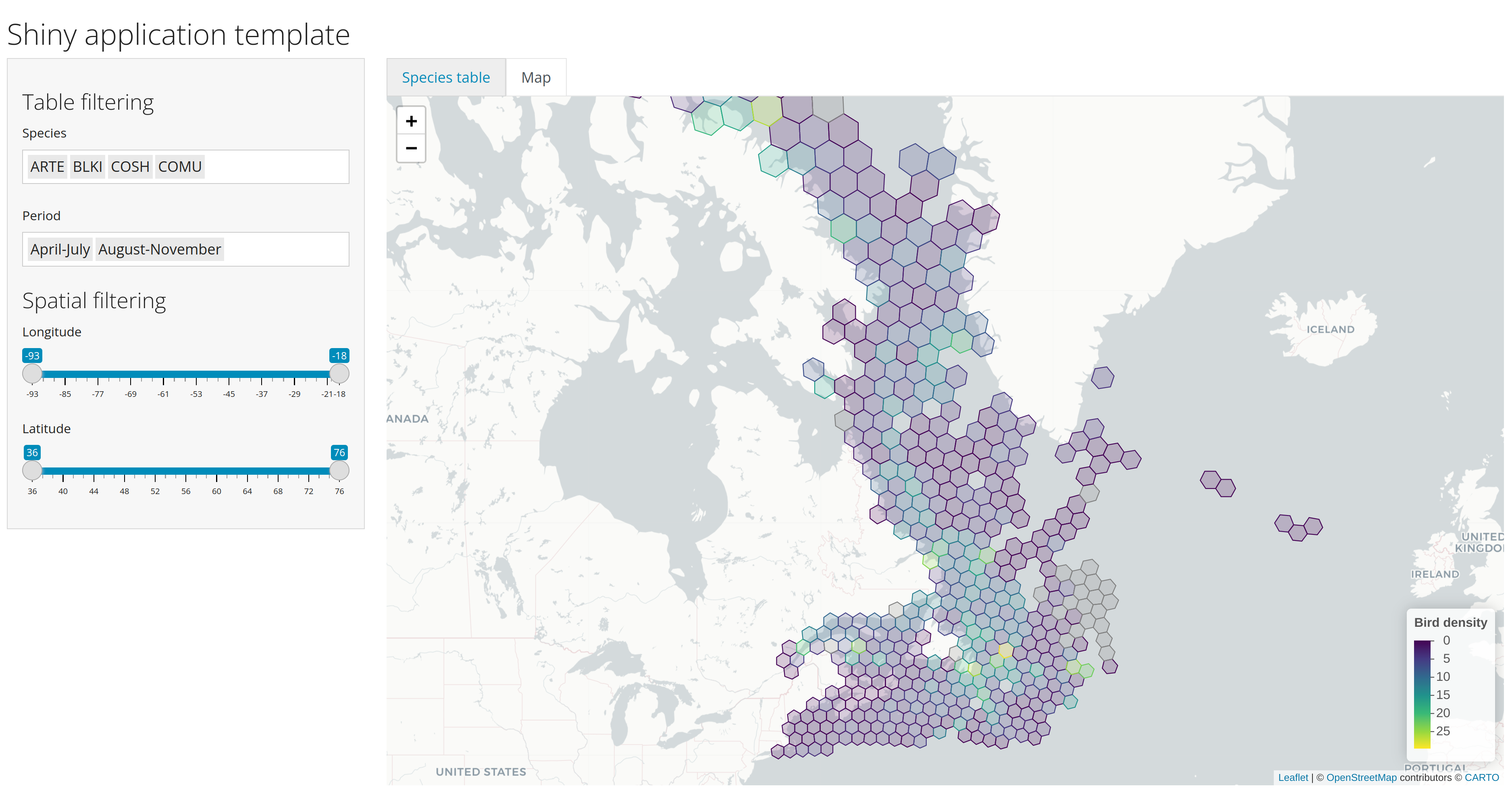 https://github.com/inSilecoInc/cws-shiny-template/blob/practice2/practice2/app.R --- # Examples ## Sky's the limit <br> -- ## Two Examples: ### 1. [*eDrivers*](https://david-beauchesne.shinyapps.io/edriversapp/) `shiny` app -- ### 2. [*Spatial Reproducible Reporting*](https://github.com/inSilecoInc/shinySpatialApp) `shiny` app